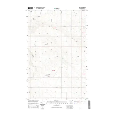
2014 Map of Peerless
USGS Topo · Published 2014About this map
Peerless serves as the primary hub of this high-plains landscape in Daniels County, centered at the intersection of MT-248 and Peerless Rd. The map illustrates a highly organized grid of rural life, where local family names and landmarks like Sundby Hill, Jones Hill, and Dighans Hill stand above the drainage basins of Police Cr and Rush Cr. The township and range boundaries of t35n r45e and t36n r45e define the sectioned prairie, with Peerless anchored by its Po and the residential grid of 3rd Ave and Railroad Ave. Further north, more evocative terrain features like Wild Horse Butte, Slaughter Hill, and Lewarton Coulee break the geometric regularity of the county roads, reflecting a landscape shaped both by agricultural intent and the natural contours of the northern Montana plains.
Find a feature on this map
28 named features on this map. Tap any name to fly to it.
Don’t see what you’re looking for? This feature index may not catch every label — zoom into the map to look around manually.
Map Details
Editions of this 2014 Peerless Map
This is the sole edition of this map. No revisions or reprints were ever made.
Other maps of this area

1954 · Wolf Point
USGS Topo · 1:250,000

1958 · Wolf Point
USGS Topo · 1:250,000

1973 · Horseshoe Basin
USGS Topo · 1:24,000

1973 · West Fork NE
USGS Topo · 1:24,000

1973 · Peerless
USGS Topo · 1:24,000

1973 · Flaherty Coulee
USGS Topo · 1:24,000

1973 · Carbert
USGS Topo · 1:24,000

1973 · Killenbeck Reservoir
USGS Topo · 1:24,000

1973 · Four Buttes NW
USGS Topo · 1:24,000
1973 · West Fork
USGS Topo · 1:24,000