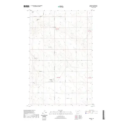
2020 Map of Peerless
USGS Topo · Published 2020About this map
Peerless serves as the central hub of this northern Montana landscape, situated at the intersection of 3rd Ave and Offett St. The surrounding terrain in Daniels County is defined by a series of prominent elevations and watercourses, including Slaughter Hill to the north and the nearby Wild Horse Butte. The drainage pattern is marked by Police Cr, which flows through the heart of the area, supplemented by Olson Coulee and Brush Cr. A network of local routes, such as Coal Creek Rd and Peerless Lustre Rd, connects the scattered topographic features and provides a glimpse into the rural infrastructure and land divisions of the early 21st century. Researchers can find several family-named landmarks like Dighans Hill and Sundby Hill, which reflect the ranching and agricultural history of this high plains region.
Find a feature on this map
30 named features on this map. Tap any name to fly to it.
Don’t see what you’re looking for? This feature index may not catch every label — zoom into the map to look around manually.
Map Details
Editions of this 2020 Peerless Map
This is the sole edition of this map. No revisions or reprints were ever made.
Other maps of this area

1954 · Wolf Point
USGS Topo · 1:250,000

1958 · Wolf Point
USGS Topo · 1:250,000

1973 · Horseshoe Basin
USGS Topo · 1:24,000

1973 · West Fork NE
USGS Topo · 1:24,000

1973 · Peerless
USGS Topo · 1:24,000

1973 · Flaherty Coulee
USGS Topo · 1:24,000

1973 · Carbert
USGS Topo · 1:24,000

1973 · Killenbeck Reservoir
USGS Topo · 1:24,000

1973 · Four Buttes NW
USGS Topo · 1:24,000
1973 · West Fork
USGS Topo · 1:24,000