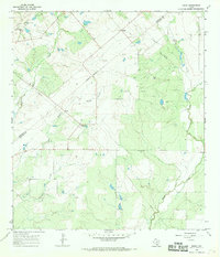
1965 Map of Peggy
USGS Topo · Published 1969About this map
Hacienda de la Tordilla and the Lipan Hills anchor the northwestern corner of this South Texas landscape, where the Atascosa and Live Oak county line runs as an indefinite boundary. The 1960s terrain is characterized by a network of drainage hollows and creeks, including Salt Hollow, Merriman Hollow, and the winding Weedy Creek. Small ranching and farming communities like Peggy, McCoy, and Esseville are connected by a web of light-duty and unimproved roads, reflecting the era's rural infrastructure before significant modern expansion.
Find a feature on this map
22 named features on this map. Tap any name to fly to it.
Don’t see what you’re looking for? This feature index may not catch every label — zoom into the map to look around manually.
Map Details
Editions of this 1965 Peggy Map
2 editions found
Other maps of this area

1930 · Whitsett
USGS Topo · 1:62,500

1931 · Falls City
USGS Topo · 1:62,500

1942 · Whitsett
USGS Topo · 1:62,500

1953 · Crystal City
USGS Topo · 1:250,000

1955 · Crystal City
USGS Topo · 1:250,000

1956 · Suniland
USGS Topo · 1:62,500

1956 · Pleasanton
USGS Topo · 1:62,500

1961 · Crystal City
USGS Topo · 1:250,000
1961 · Coy City
USGS Topo · 1:24,000
1961 · Fashing
USGS Topo · 1:24,000