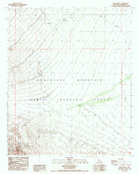
1988 Map of Pegleg Well
USGS Topo · Published 1988About this map
Chocolate Mountain dominates this desert landscape within Imperial County, serving as the backdrop for extensive military and mineral history during the late twentieth century. Much of the area falls within the Chocolate Mountain Aerial Gunnery Range, defined by the Naval Reservation Boundary. This proximity between defense and mining is evident in the southwest corner, where the Pegleg Mine and German Diggins sit near the base of the peaks. The presence of Pegleg Well suggests the critical importance of water access for early prospectors and surveyors in this arid environment. Topographic details reveal a network of drainage features like Arroyo Seco and Martinez Gulch, alongside surveying markers such as Sego SW Base and numerous unnamed prospects that speak to the region's enduring draw for mineral exploration.
Find a feature on this map
17 named features on this map. Tap any name to fly to it.
Don’t see what you’re looking for? This feature index may not catch every label — zoom into the map to look around manually.
Map Details
Editions of this 1988 Pegleg Well Map
This is the sole edition of this map. No revisions or reprints were ever made.
Other maps of this area

1940 · Iris
USGS Topo · 1:62,500

1940 · Iris Pass
USGS Topo · 1:62,500

1945 · Iris Pass
USGS Topo · 1:62,500

1945 · Iris
USGS Topo · 1:62,500

1953 · Chuckwalla Spring
USGS Topo · 1:62,500

1953 · Acolita
USGS Topo · 1:62,500

1954 · Salton Sea
USGS Topo · 1:250,000

1955 · Tortuga
USGS Topo · 1:24,000

1955 · Salton Sea
USGS Topo · 1:250,000

1959 · Salton Sea
USGS Topo · 1:250,000