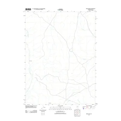
2012 Map of Peko Peak
USGS Topo · Published 2012About this map
Peko Peak and the high desert terrain of Elko County define this landscape along the upper reaches of the North Fork Humboldt River. In this early twenty-first-century survey, the drainage patterns of the Great Basin are clearly visible, with Pole Creek, Allen Creek, and Winter Creek cutting through the arid territory. A notable topographic landmark, Devils Gate, sits west of the river, marking a distinctive natural passage in the local geography. Human infrastructure is sparse here, represented primarily by CO Hwy 747 in the northeastern quadrant, reflecting the remote ranching and open-range character of the region during this era.
Find a feature on this map
7 named features on this map. Tap any name to fly to it.
Don’t see what you’re looking for? This feature index may not catch every label — zoom into the map to look around manually.
Map Details
Editions of this 2012 Peko Peak Map
This is the sole edition of this map. No revisions or reprints were ever made.
Other maps of this area

1955 · Wells
USGS Topo · 1:250,000

1958 · Wells
USGS Topo · 1:250,000

1961 · Wells
USGS Topo · 1:250,000

1967 · Hanks Creek SW
USGS Topo · 1:24,000

1967 · Hot Springs Creek
USGS Topo · 1:24,000

1967 · Twin Buttes
USGS Topo · 1:24,000

1967 · Peko Peak
USGS Topo · 1:24,000
1967 · Deeth
USGS Topo · 1:24,000
1967 · Morgan Hill
USGS Topo · 1:24,000

1971 · Double Mtn SE
USGS Topo · 1:24,000