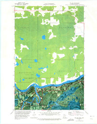
1970 Map of Pelland
USGS Topo · Published 1973About this map
The Rainy River forms a natural international boundary between Ontario and Minnesota on this orthophotomap, which combines traditional topographic data with aerial photography. The settlement of Pelland sits at the confluence where the Little Fork River meets the Rainy, a focal point for the regional timber and transport network. To the east, the small community of Isherwood and the Indian Reserve 10 occupy the riverfront, while the interior is defined by extensive wetlands and drainage patterns. Industrial and transportation history is visible in the corridor of the Canadian National railroad and the Old Railroad Grade further south. The map's photographic base reveals the distinctive land-clearing patterns in townships like Woodyatt and Roddick, contrasting the dense forest of the Little Forks area with active agricultural and resource extraction sites such as the local Gravel Pits.
Find a feature on this map
20 named features on this map. Tap any name to fly to it.
Don’t see what you’re looking for? This feature index may not catch every label — zoom into the map to look around manually.
Map Details
Editions of this 1970 Pelland Map
This is the sole edition of this map. No revisions or reprints were ever made.
Other maps of this area

1919 · Pelland
USGS Topo · 1:62,500

1919 · Happy Land
USGS Topo · 1:62,500

1919 · International Falls
USGS Topo · 1:62,500

1954 · International Falls
USGS Topo · 1:250,000

1957 · International Falls
USGS Topo · 1:250,000

1958 · International Falls
USGS Topo · 1:250,000

1969 · Ericsburg NW
USGS Topo · 1:24,000
1969 · International Falls
USGS Topo · 1:24,000

1970 · Devlin
USGS Topo · 1:24,000
1970 · Littlefork
USGS Topo · 1:24,000