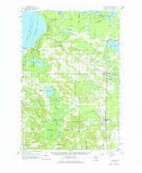
1958 Map of Pellston
USGS Topo · Published 1969About this map
Larks Lake and the dense woodlands of the Michigan Tip-of-the-Mitt define this 1958 survey, where the Hardwood State Forest and Wilderness State Park dominate the northern landscape. Small rural communities like Bliss and Levering are connected by a network of unimproved roads and the tracks of the Pennsylvania railroad, which runs south through the village of Pellston. The presence of the State Prison Camp and the Emmet County Airport highlights the mid-century infrastructure supporting this corner of the state.
Find a feature on this map
78 named features on this map. Tap any name to fly to it.
Don’t see what you’re looking for? This feature index may not catch every label — zoom into the map to look around manually.
Map Details
Editions of this 1958 Pellston Map
2 editions found
Other maps of this area

1955 · Cheboygan
USGS Topo · 1:250,000

1957 · Wolverine
USGS Topo · 1:62,500

1957 · Mullett Lake
USGS Topo · 1:62,500

1958 · Cheboygan
USGS Topo · 1:250,000

1958 · Cross Village
USGS Topo · 1:62,500

1958 · Pellston
USGS Topo · 1:62,500

1958 · Bayshore
USGS Topo · 1:62,500

1958 · Petoskey
USGS Topo · 1:62,500

1964 · Big Stone Bay
USGS Topo · 1:24,000
1964 · St. Ignace
USGS Topo · 1:24,000