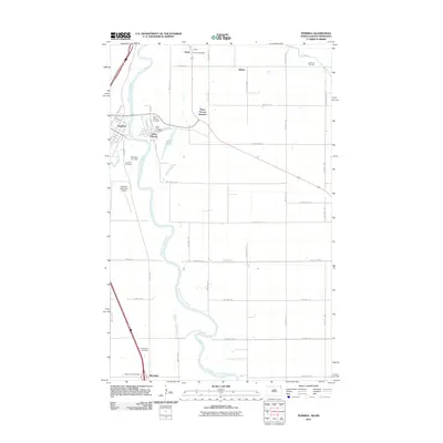
2011 Map of Pembina
USGS Topo · Published 2011About this map
Red River of the North serves as the winding natural boundary between North Dakota and Minnesota in this borderland survey. The landscape is defined by the intersection of river transport and rail history, where the community of Pembina sits across from Saint Vincent. The map documents a cluster of civic and spiritual centers, including the Saint Vincent Post Office, Lutheran Cemetery, and Evangelical Cemetery. Further north, the international crossing at Noyes is highlighted by the Noyes Post Office and the nearby Joe River. The straight lines of county and township roads, such as County Hwy-21 and County Hwy-16, contrast sharply with the meandering path of the Pembina River, illustrating the systematic agricultural platting typical of the Red River Valley. This record also identifies infrastructure like the Pembina City Dam and Pembina Municipal Airport, alongside smaller railway-adjacent locales like Saint Vincent Junction and Sultan.
Find a feature on this map
54 named features on this map. Tap any name to fly to it.
Don’t see what you’re looking for? This feature index may not catch every label — zoom into the map to look around manually.
Map Details
Editions of this 2011 Pembina Map
This is the sole edition of this map. No revisions or reprints were ever made.
Other maps of this area

1939 · Pembina
USGS Topo · 1:62,500

1941 · Bathgate
USGS Topo · 1:62,500

1941 · Pembina
USGS Topo · 1:62,500

1952 · Thief River Falls
USGS Topo · 1:250,000

1956 · Thief River Falls
USGS Topo · 1:250,000

1957 · Thief River Falls
USGS Topo · 1:250,000

1967 · Thief River Falls
USGS Topo · 1:250,000
1970 · Bathgate SE
USGS Topo · 1:24,000
1970 · Bathgate NE
USGS Topo · 1:24,000
1972 · Joliette
USGS Topo · 1:24,000