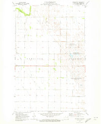
1970 Map of Bathgate SE
USGS Topo · Published 1973About this map
Pembina Prairie National Wildlife Management Area and its neighbors define this corner of Pembina County, reflecting a landscape where conservation efforts intersect with an intensive agricultural drainage network. The area between Carlisle and Joliette townships is marked by an intricate system of man-made waterways, including a prominent Pipeline and several segments of a named Ditch, which redirect water across the flat terrain. Natural hydrology is represented by the winding Tongue River in the northwest and the Big Slough to the south. Unique geological or hydrological features such as the Flowing Salt Well near the Juhl National Wildlife Management Area hint at the underlying saline characteristics of the Red River Valley’s groundwater. A small Landing Strip suggests the importance of aerial access for crop dusting or local travel in this productive farming region.
Find a feature on this map
12 named features on this map. Tap any name to fly to it.
Don’t see what you’re looking for? This feature index may not catch every label — zoom into the map to look around manually.
Map Details
Editions of this 1970 Bathgate SE Map
This is the sole edition of this map. No revisions or reprints were ever made.
Other maps of this area

1939 · Drayton
USGS Topo · 1:62,500

1939 · Glasston
USGS Topo · 1:62,500

1939 · Pembina
USGS Topo · 1:62,500

1941 · Drayton
USGS Topo · 1:62,500

1941 · Glasston
USGS Topo · 1:62,500

1941 · Bathgate
USGS Topo · 1:62,500

1941 · Pembina
USGS Topo · 1:62,500

1952 · Thief River Falls
USGS Topo · 1:250,000

1956 · Thief River Falls
USGS Topo · 1:250,000

1957 · Thief River Falls
USGS Topo · 1:250,000