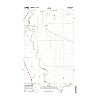
2014 Map of Pembina
USGS Topo · Published 2014About this map
The Red River of the North winds along the border of North Dakota and Minnesota, defining the landscape of this international frontier. In the early 21st century, the town of Pembina serves as a primary hub, situated where the Pembina River joins the main northern flow. The map reveals the intricate network of roads and rail lines that cross the border, including Saint Vincent Junction and the small settlement of Noyes at the Canadian line. Local history is preserved in scattered sites such as the Saint Vincent Cem, Lutheran Cem, and Evangelical Cem, reflecting the early settlement patterns of the Red River Valley. Infrastructure like the Pembina Municipal Airport and names like Great Northern Ave in St. Vincent speak to the area's continued importance as a transportation corridor between the United States and Canada.
Find a feature on this map
60 named features on this map. Tap any name to fly to it.
Don’t see what you’re looking for? This feature index may not catch every label — zoom into the map to look around manually.
Map Details
Editions of this 2014 Pembina Map
This is the sole edition of this map. No revisions or reprints were ever made.
Other maps of this area

1939 · Pembina
USGS Topo · 1:62,500

1941 · Bathgate
USGS Topo · 1:62,500

1941 · Pembina
USGS Topo · 1:62,500

1952 · Thief River Falls
USGS Topo · 1:250,000

1956 · Thief River Falls
USGS Topo · 1:250,000

1957 · Thief River Falls
USGS Topo · 1:250,000

1967 · Thief River Falls
USGS Topo · 1:250,000
1970 · Bathgate SE
USGS Topo · 1:24,000
1970 · Bathgate NE
USGS Topo · 1:24,000
1972 · Joliette
USGS Topo · 1:24,000