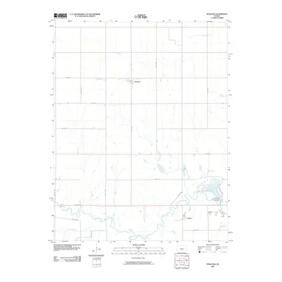
2009 Map of Penalosa
USGS Topo · Published 2009About this map
Penalosa and the surrounding prairie of Kingman County are documented here as they appeared in the early 21st century. The landscape is defined by the winding course of the South Fork Ninnescah River, which meanders through the southern portion of the area, joined by tributaries like Painter Creek. The local economy is visibly shaped by the rigid section-line road grid, which accommodates the region's agricultural traditions while connecting small communities via routes like US Hwy 54. A major regional landmark, the Kingman County State Lake, occupies the eastern edge of the survey, created by the Kingman County State Lake Dam. Further north, Goose Creek cuts through the open terrain, illustrating the drainage patterns that have dictated settlement and land use since the late 19th century. The smaller settlement of Calista sits near the river's bend, serving as a quiet node in the rural transportation network.
Find a feature on this map
26 named features on this map. Tap any name to fly to it.
Don’t see what you’re looking for? This feature index may not catch every label — zoom into the map to look around manually.
Map Details
Editions of this 2009 Penalosa Map
This is the sole edition of this map. No revisions or reprints were ever made.
Other maps of this area

1892 · Kingman
USGS Topo · 1:125,000

1894 · Kingman
USGS Topo · 1:125,000

1955 · Pratt
USGS Topo · 1:250,000

1959 · Pratt
USGS Topo · 1:250,000

1966 · Cunningham
USGS Topo · 1:24,000
1966 · St Leo
USGS Topo · 1:24,000

1967 · Kingman NW
USGS Topo · 1:24,000

1967 · Cleveland
USGS Topo · 1:24,000
1967 · Willowdale
USGS Topo · 1:24,000

1967 · Penalosa
USGS Topo · 1:24,000