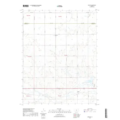
2018 Map of Penalosa
USGS Topo · Published 2018About this map
The South Fork Ninnescah River meanders across the southern reaches of Kingman County, shaping a prairie landscape of intermittent creeks and agricultural grid roads. Small rural hubs like Penalosa and Calista anchor this region, reflecting the steady agrarian character of south-central Kansas. The terrain is defined by a dendritic drainage pattern where Goose Cr and Smoots Creek feed into larger systems, eventually meeting the prominent water feature of the Kingman County State Lake in the southeast. This 2018 survey documents a region defined by its sections and townships, including t27s r9w, where the network of local connectors like Maple Grove Rd and Lerado Rd facilitate movement between the scattered farmsteads and the watercourses of Painter Cr and Mead Cr.
Find a feature on this map
47 named features on this map. Tap any name to fly to it.
Don’t see what you’re looking for? This feature index may not catch every label — zoom into the map to look around manually.
Map Details
Editions of this 2018 Penalosa Map
This is the sole edition of this map. No revisions or reprints were ever made.
Other maps of this area

1892 · Kingman
USGS Topo · 1:125,000

1894 · Kingman
USGS Topo · 1:125,000

1955 · Pratt
USGS Topo · 1:250,000

1959 · Pratt
USGS Topo · 1:250,000

1966 · Cunningham
USGS Topo · 1:24,000
1966 · St Leo
USGS Topo · 1:24,000

1967 · Kingman NW
USGS Topo · 1:24,000

1967 · Cleveland
USGS Topo · 1:24,000
1967 · Willowdale
USGS Topo · 1:24,000

1967 · Penalosa
USGS Topo · 1:24,000