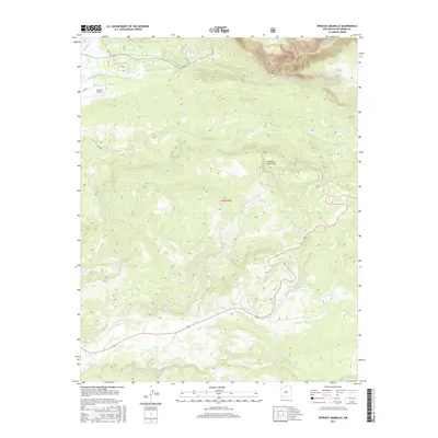
2017 Map of Penasco Amarillo
USGS Topo · Published 2017About this map
Brazos Cliffs dominate the northeastern corner of this Rio Arriba County landscape, marking a dramatic elevation shift near the Brazos Box. The terrain is defined by a complex network of watercourses that drain the high country, including the Rio Brazos and the south-flowing Rito de Tierra Amarilla. In the northwest, the presence of the Ensenada Ditch and the Ensenada Airport indicates a pocket of infrastructure tied to the lower elevations and nearby settlements. The map transition from the sharp relief of Peñasco Amarillo to the more gradual southern reaches, where Rio Nutrias and Rito de la Agua Fria converge, illustrates the high-altitude hydrology of northern New Mexico. Local transit is represented by several forest routes and residential lanes such as Peary Ln and Aspen Ln, providing access to this varied landscape.
Find a feature on this map
20 named features on this map. Tap any name to fly to it.
Don’t see what you’re looking for? This feature index may not catch every label — zoom into the map to look around manually.
Map Details
Editions of this 2017 Penasco Amarillo Map
This is the sole edition of this map. No revisions or reprints were ever made.
Other maps of this area

1918 · Tusas
USGS Topo · 1:125,000

1954 · Aztec
USGS Topo · 1:250,000

1955 · Chama
USGS Topo · 1:62,500

1955 · Cebolla
USGS Topo · 1:62,500

1955 · Brazos Peak
USGS Topo · 1:62,500

1955 · Tierra Amarilla
USGS Topo · 1:62,500

1958 · Aztec
USGS Topo · 1:250,000

1962 · Aztec
USGS Topo · 1:250,000

1965 · Aztec
USGS Topo · 1:250,000

1981 · Chama
USGS Topo · 1:100,000