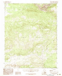
1983 Map of Penasco Amarillo
USGS Topo · Published 1983About this map
Tierra Amarilla Grant Bdy defines much of this Northern New Mexico high-country landscape, established as a provisional study in the early 1980s. The terrain is dominated by the dramatic Brazos Cliffs and the course of the Rio Brazos, where water management for early ranching or agriculture is evidenced by the Park Ditch and View Ditch. This area, centered on the Peñasco Amarillo landmark, shows a landscape transition where numerous mountain drainages like Encinado Creek and the Rito de Tierra Amarilla converge. A single Prospect noted near the peaks suggests the era's limited mineral exploration, while a solitary Jeep Trail provides the only significant vehicular access into these elevations. The map serves as a detailed record of the hydrography and land grant boundaries that have long shaped land use in Rio Arriba County.
Find a feature on this map
15 named features on this map. Tap any name to fly to it.
Don’t see what you’re looking for? This feature index may not catch every label — zoom into the map to look around manually.
Map Details
Editions of this 1983 Penasco Amarillo Map
This is the sole edition of this map. No revisions or reprints were ever made.
Other maps of this area

1918 · Tusas
USGS Topo · 1:125,000

1954 · Aztec
USGS Topo · 1:250,000

1955 · Chama
USGS Topo · 1:62,500

1955 · Cebolla
USGS Topo · 1:62,500

1955 · Brazos Peak
USGS Topo · 1:62,500

1955 · Tierra Amarilla
USGS Topo · 1:62,500

1958 · Aztec
USGS Topo · 1:250,000

1962 · Aztec
USGS Topo · 1:250,000

1965 · Aztec
USGS Topo · 1:250,000

1981 · Chama
USGS Topo · 1:100,000