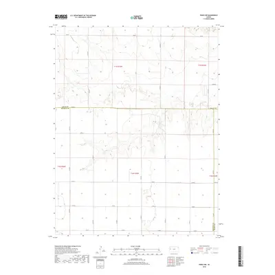
2018 Map of Pence NW
USGS Topo · Published 2018About this map
Wichita County, Logan County, and Scott County converge in this high plains landscape of western Kansas. The terrain is defined by the stark transition from flat upland sections to the intricate, branching drainage systems that carve through the Dakota formations. This 2018 survey reveals a highly organized township and range grid, where section lines are strictly maintained by a network of rural routes such as Co Rd 19, Co Rd 240, and Co Rd 270. The sparse human footprint is limited to scattered agricultural structures and the long east-west thoroughfares of Adobe Rd and Bison Rd. The intricate contour lines illustrate the subtle but complex erosion patterns typical of this semi-arid region, providing a clear view of the draw and canyon topography that breaks the level horizon of the prairie.
Find a feature on this map
26 named features on this map. Tap any name to fly to it.
Don’t see what you’re looking for? This feature index may not catch every label — zoom into the map to look around manually.
Map Details
Editions of this 2018 Pence NW Map
This is the sole edition of this map. No revisions or reprints were ever made.
Other maps of this area

1939 · Pence
USGS Topo · 1:62,500

1941 · Pence
USGS Topo · 1:62,500

1955 · Scott City
USGS Topo · 1:250,000

1958 · Scott City
USGS Topo · 1:250,000

1968 · Russell Springs 3 SE
USGS Topo · 1:24,000

1968 · Russell Springs 3 NE
USGS Topo · 1:24,000

1969 · Russell Springs 2 SE
USGS Topo · 1:24,000
1974 · Lone Butte
USGS Topo · 1:24,000
1974 · Russell Springs SE
USGS Topo · 1:24,000
1976 · Pence
USGS Topo · 1:24,000