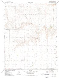
1976 Map of Pence NW
USGS Topo · Published 1978About this map
Chalk Creek winds through the northern portion of this landscape, carving through the high plains terrain of western Kansas. Surveyed in the mid-1970s, the area reflects a specialized aviation and energy infrastructure, featuring both the Kough Landing Strip and the RWR Landing Field alongside a significant underground Pipeline network. The land is divided between the Paxton and Leoti townships, where the presence of numerous wells and a Gravel Pit indicates a landscape defined by resource extraction and rural utility. This map captures the administrative boundaries at the intersection of Logan, Wichita, and Scott counties, providing a clear record of the spatial organization and transport hubs essential to this agricultural region during the late twentieth century.
Find a feature on this map
10 named features on this map. Tap any name to fly to it.
Don’t see what you’re looking for? This feature index may not catch every label — zoom into the map to look around manually.
Map Details
Editions of this 1976 Pence NW Map
This is the sole edition of this map. No revisions or reprints were ever made.
Other maps of this area

1939 · Pence
USGS Topo · 1:62,500

1941 · Pence
USGS Topo · 1:62,500

1955 · Scott City
USGS Topo · 1:250,000

1958 · Scott City
USGS Topo · 1:250,000

1968 · Russell Springs 3 SE
USGS Topo · 1:24,000

1968 · Russell Springs 3 NE
USGS Topo · 1:24,000

1969 · Russell Springs 2 SE
USGS Topo · 1:24,000
1974 · Lone Butte
USGS Topo · 1:24,000
1974 · Russell Springs SE
USGS Topo · 1:24,000
1976 · Pence
USGS Topo · 1:24,000