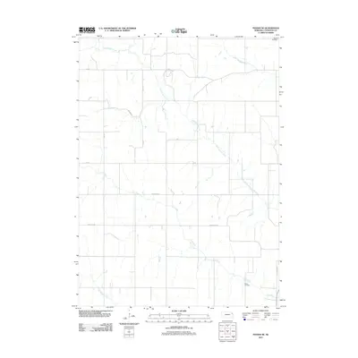
2011 Map of Pender NE
USGS Topo · Published 2011About this map
North Omaha Creek and Cow Creek meander across this landscape in Thurston County, shaping a rural environment defined by a strict grid of section roads and agricultural boundaries. This 2011 survey illustrates the late-twentieth-century spatial organization of the Nebraska countryside, where long thoroughfares like Thurston Rd and Emerson Rd connect isolated farmsteads and open fields. For those tracing local heritage, the map identifies specific points of historical significance, including Pilcher Cemetery in the southeast and Meseal Cemetery in the northeast corner. The presence of The Strip Rd and Mathewson St alongside natural waterways like Morgan Creek provides a clear view of how modern transportation corridors have been laid over the area's original hydrological features.
Find a feature on this map
16 named features on this map. Tap any name to fly to it.
Don’t see what you’re looking for? This feature index may not catch every label — zoom into the map to look around manually.
Map Details
Editions of this 2011 Pender NE Map
This is the sole edition of this map. No revisions or reprints were ever made.
Other maps of this area

1955 · Sioux City
USGS Topo · 1:250,000

1958 · Sioux City
USGS Topo · 1:250,000

1959 · Sioux City
USGS Topo · 1:250,000

1964 · Homer
USGS Topo · 1:24,000

1966 · Walthill SW
USGS Topo · 1:24,000

1966 · Walthill
USGS Topo · 1:24,000
1966 · Bancroft
USGS Topo · 1:24,000

1966 · Thurston
USGS Topo · 1:24,000

1966 · Pender NE
USGS Topo · 1:24,000
1966 · Pender
USGS Topo · 1:24,000