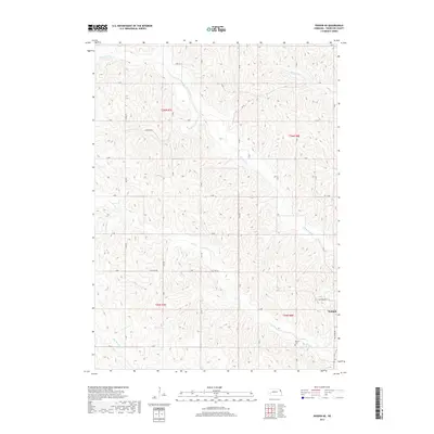
2017 Map of Pender NE
USGS Topo · Published 2017About this map
The village of Walthill occupies the southeastern corner of this terrain, where the Missouri River breaks into a complex network of dissected hills and drainage basins. This landscape is defined by the headwaters of N Omaha Cr and Cow Cr, which carve deep, winding valleys through the Nebraska countryside. The survey captures a high-resolution view of rural Thurston County land divisions, including the boundaries of t26n r7e and t25n r8e. Genealogists may find value in the location of the Pilcher Cem, situated on a ridge above the Cow Cr valley near Balltown Rd. The road network, including thoroughfares like Emerson Rd and The Strip Rd, reflects the section-line grid typical of the Great Plains, providing a clear window into early 21st-century property access and local transportation patterns.
Find a feature on this map
34 named features on this map. Tap any name to fly to it.
Don’t see what you’re looking for? This feature index may not catch every label — zoom into the map to look around manually.
Map Details
Editions of this 2017 Pender NE Map
This is the sole edition of this map. No revisions or reprints were ever made.
Other maps of this area

1955 · Sioux City
USGS Topo · 1:250,000

1958 · Sioux City
USGS Topo · 1:250,000

1959 · Sioux City
USGS Topo · 1:250,000

1964 · Homer
USGS Topo · 1:24,000

1966 · Walthill SW
USGS Topo · 1:24,000

1966 · Walthill
USGS Topo · 1:24,000
1966 · Bancroft
USGS Topo · 1:24,000

1966 · Thurston
USGS Topo · 1:24,000

1966 · Pender NE
USGS Topo · 1:24,000
1966 · Pender
USGS Topo · 1:24,000