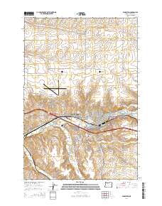
2014 Map of Pendleton
USGS Topo · Published 2014About this map
Pendleton serves as the hub of this 2014 survey, where the Umatilla River and its many tributaries, including McKay Cr and Tutuilla Cr, converge. The landscape is a mix of urban development and high plateau agriculture, defined by the prominent Eastern Oregon Regional At Pendleton Airport on the bluff at Pendair Heights. The map records the institutional footprint of the area, from the Blue Mtn Community Coll campus to the Olney Cem south of the city center.
Find a feature on this map
61 named features on this map. Tap any name to fly to it.
Don’t see what you’re looking for? This feature index may not catch every label — zoom into the map to look around manually.
Map Details
Editions of this 2014 Pendleton Map
This is the sole edition of this map. No revisions or reprints were ever made.
Other maps of this area

1935 · Pendleton
USGS Topo · 1:125,000

1953 · Pendleton
USGS Topo · 1:250,000

1956 · Pendleton
USGS Topo · 1:250,000

1966 · Mc Kay Reservoir
USGS Topo · 1:24,000

1966 · Holdman
USGS Topo · 1:24,000

1966 · Holdman SE
USGS Topo · 1:24,000

1966 · Table Rock
USGS Topo · 1:24,000

1966 · Pendleton
USGS Topo · 1:24,000

1966 · Mission
USGS Topo · 1:24,000
1966 · Helix
USGS Topo · 1:24,000