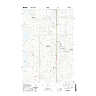
2016 Map of Pennington
USGS Topo · Published 2016About this map
Pennington serves as the primary settlement on this northern Minnesota landscape, situated just south of where Sucker Cr enters Kitchi Lake. The map reveals a densely wooded and water-heavy environment protected within the Chippewa National Forest, where the legendary Mississippi River meanders through the central terrain between Cass Lake and Lydick Lake. This 2016 survey captures the complex hydrology of the region, including the Grass Lake Impoundment and numerous smaller basins like Minny Lake and Mark Lake. A network of forest roads and logging routes, such as 2948 Logging Rd and Tower Lake Hwt D, crisscrosses the timberlands. The convergence of three county lines—Beltrami, Cass, and Itasca—near the Bald Eagle Center highlights the jurisdictional complexity of this lake-dotted wilderness, which remains a focal point for conservation and timber management.
Find a feature on this map
46 named features on this map. Tap any name to fly to it.
Don’t see what you’re looking for? This feature index may not catch every label — zoom into the map to look around manually.
Map Details
Editions of this 2016 Pennington Map
This is the sole edition of this map. No revisions or reprints were ever made.
Other maps of this area

1919 · Rosy
USGS Topo · 1:62,500

1954 · Bemidji
USGS Topo · 1:250,000

1957 · Bemidji
USGS Topo · 1:250,000

1958 · Bemidji
USGS Topo · 1:250,000

1971 · Dixon Lake
USGS Topo · 1:24,000

1971 · Gimmer Lake
USGS Topo · 1:24,000

1971 · Raven Lake
USGS Topo · 1:24,000

1971 · Sucker Lakes
USGS Topo · 1:24,000

1971 · Pennington
USGS Topo · 1:24,000

1971 · Portage Lake
USGS Topo · 1:24,000