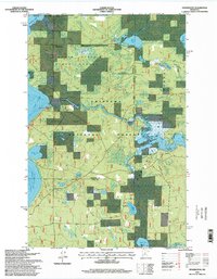
1996 Map of Pennington
USGS Topo · Published 1998About this map
Pennington sits at the heart of a densely forested landscape defined by the convergence of the Mississippi River and several major glacial lakes. This late-twentieth-century survey reveals a region managed for both conservation and recreation, where the Buena Vista State Forest meets the Chippewa National Forest. The presence of the Knutson Dam at the outlet of Cass Lake highlights the managed hydrology of the upper Mississippi watershed. Further inland, the Tower Lake Hunter Walker Trails weave through a mosaic of timber and wetlands, reflecting the area's use for seasonal outdoor activity. Smaller water bodies like Lydick Lake, Burns Lake, and the Cub Impoundment dot the terrain, while scattered gravel and sand pits indicate the localized resource extraction necessary for maintaining the rural road network in Beltrami County.
Find a feature on this map
30 named features on this map. Tap any name to fly to it.
Don’t see what you’re looking for? This feature index may not catch every label — zoom into the map to look around manually.
Map Details
Editions of this 1996 Pennington Map
This is the sole edition of this map. No revisions or reprints were ever made.
Other maps of this area

1919 · Rosy
USGS Topo · 1:62,500

1954 · Bemidji
USGS Topo · 1:250,000

1957 · Bemidji
USGS Topo · 1:250,000

1958 · Bemidji
USGS Topo · 1:250,000

1971 · Dixon Lake
USGS Topo · 1:24,000

1971 · Gimmer Lake
USGS Topo · 1:24,000

1971 · Raven Lake
USGS Topo · 1:24,000

1971 · Sucker Lakes
USGS Topo · 1:24,000

1971 · Pennington
USGS Topo · 1:24,000

1971 · Portage Lake
USGS Topo · 1:24,000