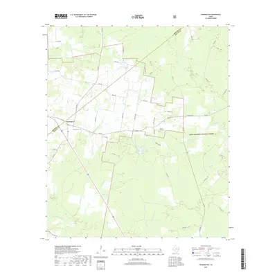
2019 Map of Pennington
USGS Topo · Published 2019About this map
Pennington sits at the intersection of FM 2781 and FM 358, serving as a focal point for the rural landscape spanning the Houston Co Trinity Co line. This part of East Texas is defined by its deep woods and network of creeks, much of which is protected within the Davy Crockett National Forest. The map provides a clear picture of local land use, from the managed timberlands of the forest to the private lakefronts of Lake Pennington and Westbrook Lake. Genealogists will find the locations of the Pennington Cem and the distinctly named Possum Walk Cem particularly valuable for tracing local family histories. The drainage patterns of Little White Rock Cr, Brownlee Cr, and Caney Cr reveal the natural topography that has influenced road placement and property boundaries in this region for generations.
Find a feature on this map
47 named features on this map. Tap any name to fly to it.
Don’t see what you’re looking for? This feature index may not catch every label — zoom into the map to look around manually.
Map Details
Editions of this 2019 Pennington Map
This is the sole edition of this map. No revisions or reprints were ever made.
Other maps of this area

1950 · Centralia
USGS Topo · 1:24,000

1951 · Kennard
USGS Topo · 1:24,000

1951 · Centralia
USGS Topo · 1:24,000

1951 · Berea
USGS Topo · 1:24,000

1953 · Palestine
USGS Topo · 1:250,000

1957 · Palestine
USGS Topo · 1:250,000

1962 · Glendale
USGS Topo · 1:24,000

1963 · Crecy
USGS Topo · 1:24,000

1963 · Groveton West
USGS Topo · 1:24,000
1963 · Pennington
USGS Topo · 1:24,000