
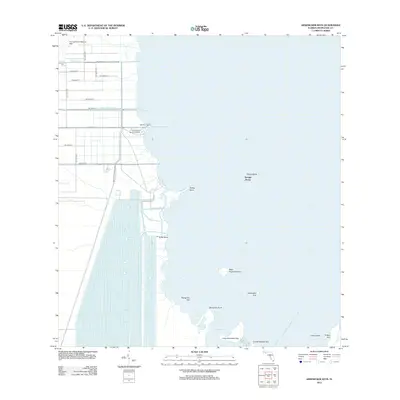
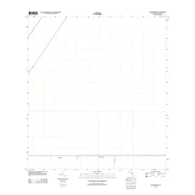
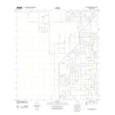
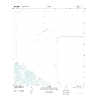
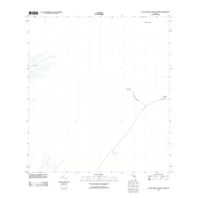
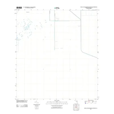
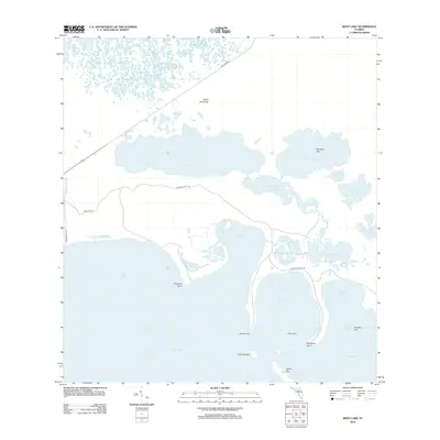
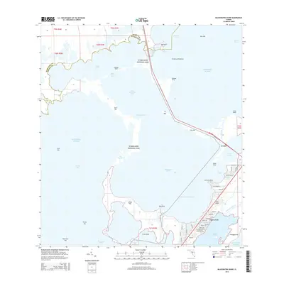
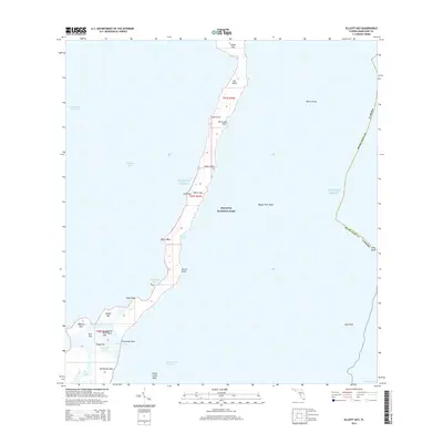
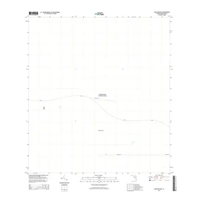
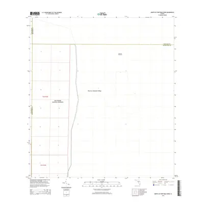
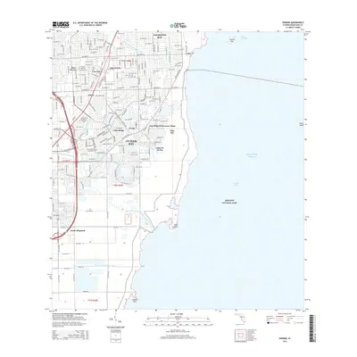
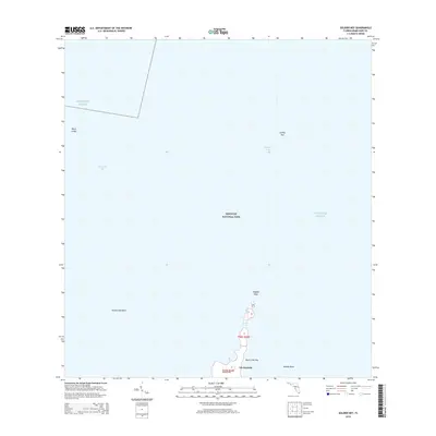
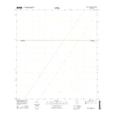
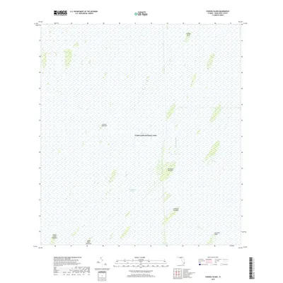
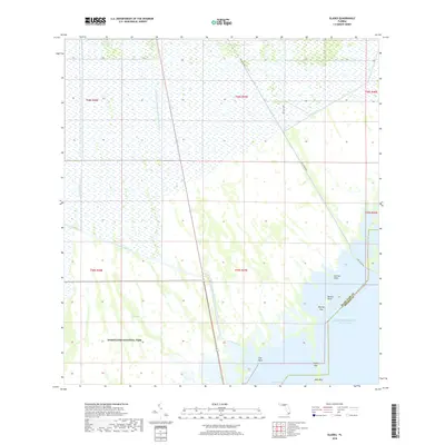
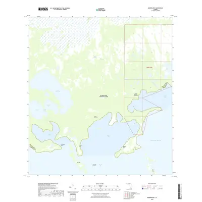
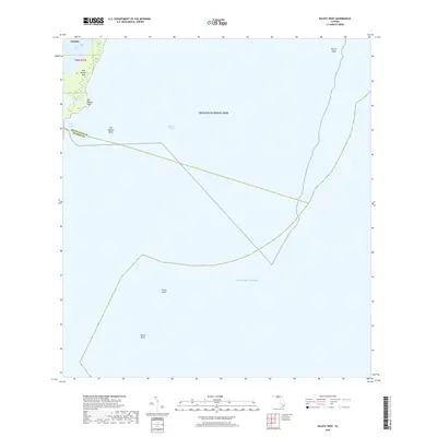
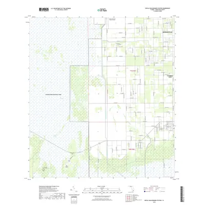
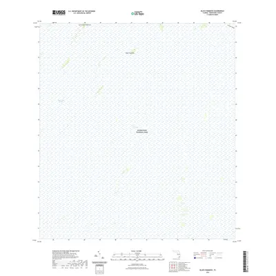
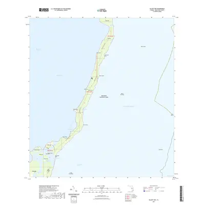
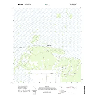
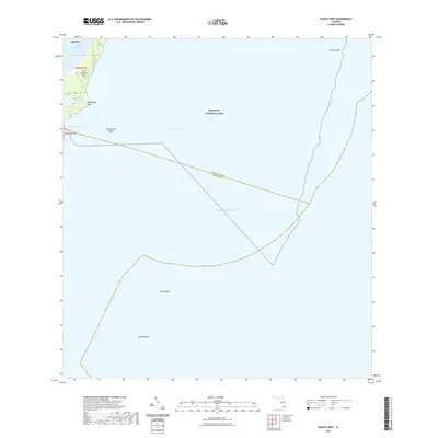
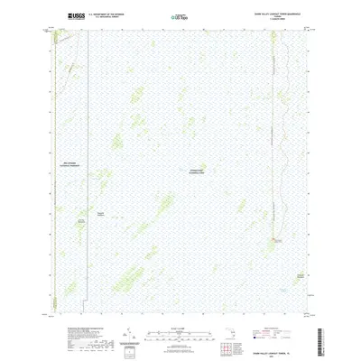
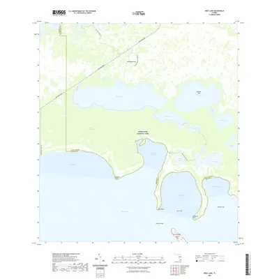
1994 Map of Pennsuco
USGS Topo · Published 2000About this map
The Everglades and Francis S Taylor Wildlife Management Area dominates the western half of this Florida landscape, where water is periodically impounded for conservation. In the mid-1990s, the boundary between Dade and Broward counties cut through a region transitioning from raw wetland to heavy industrial and suburban use. To the east, the Opa-Locka West Airport and numerous Quarries reflect the intensive land use of the era, while the small settlement of Pennsuco sits near the junction of Floridas Turnpike and the Miami Canal. This period of development is marked by the construction of the East Coast Buffer and the Everglades Buffer Strip, designed to separate the expanding suburban footprints of Pembroke Pines and Miramar from the delicate ecosystems of The Pocket.
Find a feature on this map
30 named features on this map. Tap any name to fly to it.
Don’t see what you’re looking for? This feature index may not catch every label — zoom into the map to look around manually.
Map Details
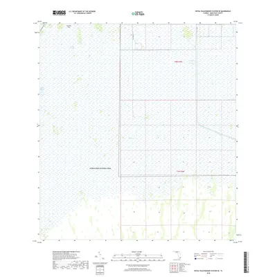
Editions of this 1994 Pennsuco Map
This is the sole edition of this map. No revisions or reprints were ever made.
Historical Maps of Medley Through Time
218 maps found

1947 Blackwater Sound
Miami-Dade County, FL

1948 Soldier Key
Miami-Dade County, FL

1949 Arsenicker Keys
Miami-Dade County, FL

1949 Blackwater Sound
Miami-Dade County, FL

1949 Elliott Key
Miami-Dade County, FL

1949 Opalocka
Miami-Dade County, FL

1949 Pacific Reef
Miami-Dade County, FL

1949 Perrine
Miami-Dade County, FL

1949 South Miami NW
Miami-Dade County, FL

1950 Glades
Miami-Dade County, FL

1955 South Miami NW
Miami-Dade County, FL

1956 Arsenicker Keys
Miami-Dade County, FL

1956 Elliott Key
Miami-Dade County, FL

1956 Glades
Miami-Dade County, FL

1956 Grossman Hammock
Miami-Dade County, FL

1956 Pacific Reef
Miami-Dade County, FL

1956 Perrine
Miami-Dade County, FL

1956 Royal Palm Ranger Station
Miami-Dade County, FL

1956 Royal Palm Ranger Station SE
Miami-Dade County, FL

1956 Soldier Key
Miami-Dade County, FL

1963 Pennsuco
Miami-Dade County, FL

1967 Royal Palm Ranger Station SE
Miami-Dade County, FL

1972 Black Hammock
Miami-Dade County, FL

1972 Chekika Island
Miami-Dade County, FL

1972 Long Pine Key
Miami-Dade County, FL

1972 Madeira Bay
Miami-Dade County, FL

1972 Mahogany Hammock
Miami-Dade County, FL

1972 Pa Hay Okee Lookout Tower
Miami-Dade County, FL

1972 Panther Mound
Miami-Dade County, FL

1972 Shark Valley Lookout Tower
Miami-Dade County, FL

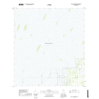
1972 South Of Coopertown
Miami-Dade County, FL

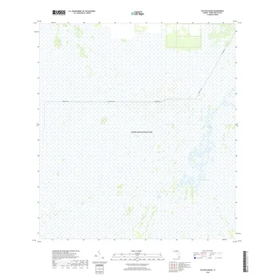
1972 Taylor Slough
Miami-Dade County, FL

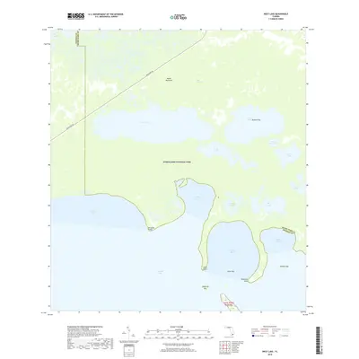
1972 West Lake
Miami-Dade County, FL

1973 Coopertown
Miami-Dade County, FL

1973 Custard Apple Hammock
Miami-Dade County, FL

1973 Fortymile Bend
Miami-Dade County, FL

1973 Hialeah SW
Miami-Dade County, FL

1973 Long Island
Miami-Dade County, FL

1973 North Of Fortymile Bend
Miami-Dade County, FL

1973 West Of Pennsuco
Miami-Dade County, FL

1988 Arsenicker Keys
Miami-Dade County, FL

1988 Elliott Key
Miami-Dade County, FL

1988 Glades
Miami-Dade County, FL

1988 Hialeah SW
Miami-Dade County, FL

1988 Opa-Locka
Miami-Dade County, FL

1988 Pacific Reef
Miami-Dade County, FL

1988 Pennsuco
Miami-Dade County, FL

1988 Perrine
Miami-Dade County, FL

1988 Soldier Key
Miami-Dade County, FL

1988 South Miami NW
Miami-Dade County, FL

1994 Glades
Miami-Dade County, FL
1994 Pennsuco
Miami-Dade County, FL

1994 Perrine
Miami-Dade County, FL

1994 South Miami NW
Miami-Dade County, FL

1995 Fortymile Bend
Miami-Dade County, FL

1995 Hialeah SW
Miami-Dade County, FL

1995 North Of Fortymile Bend
Miami-Dade County, FL

1997 Arsenicker Keys
Miami-Dade County, FL
2012 Arsenicker Keys
Miami-Dade County, FL
2012 Black Hammock
Miami-Dade County, FL
2012 Blackwater Sound
Miami-Dade County, FL
2012 Chekika Island
Miami-Dade County, FL
2012 Coopertown
Miami-Dade County, FL
2012 Custard Apple Hammock
Miami-Dade County, FL
2012 Elliott Key
Miami-Dade County, FL

2012 Fortymile Bend
Miami-Dade County, FL
2012 Glades
Miami-Dade County, FL
2012 Grossman Hammock
Miami-Dade County, FL

2012 Hialeah SW
Miami-Dade County, FL
2012 Long Island
Miami-Dade County, FL
2012 Long Pine Key
Miami-Dade County, FL
2012 Madeira Bay
Miami-Dade County, FL
2012 Mahogany Hammock
Miami-Dade County, FL

2012 Miami OE E
Miami-Dade County, FL
2012 North Miami OE E
Miami-Dade County, FL
2012 North of Fortymile Bend
Miami-Dade County, FL
2012 Pacific Reef
Miami-Dade County, FL
2012 Pa-Hay-Okee Lookout Tower
Miami-Dade County, FL
2012 Panther Mound
Miami-Dade County, FL

2012 Pennsuco
Miami-Dade County, FL
2012 Perrine
Miami-Dade County, FL
2012 Royal Palm Ranger Station
Miami-Dade County, FL
2012 Royal Palm Ranger Station SE
Miami-Dade County, FL
2012 Shark Valley Lookout Tower
Miami-Dade County, FL

2012 Soldier Key
Miami-Dade County, FL

2012 South Miami NW
Miami-Dade County, FL
2012 South of Coopertown
Miami-Dade County, FL
2012 Taylor Slough
Miami-Dade County, FL
2012 West Lake
Miami-Dade County, FL
2012 West of Pennsuco
Miami-Dade County, FL
2015 Arsenicker Keys
Miami-Dade County, FL
2015 Black Hammock
Miami-Dade County, FL
2015 Blackwater Sound
Miami-Dade County, FL
2015 Chekika Island
Miami-Dade County, FL
2015 Coopertown
Miami-Dade County, FL
2015 Custard Apple Hammock
Miami-Dade County, FL
2015 Elliott Key
Miami-Dade County, FL

2015 Fortymile Bend
Miami-Dade County, FL
2015 Glades
Miami-Dade County, FL
2015 Grossman Hammock
Miami-Dade County, FL

2015 Hialeah SW
Miami-Dade County, FL
2015 Long Island
Miami-Dade County, FL
2015 Long Pine Key
Miami-Dade County, FL
2015 Madeira Bay
Miami-Dade County, FL
2015 Mahogany Hammock
Miami-Dade County, FL

2015 Miami OE E
Miami-Dade County, FL
2015 North Miami OE E
Miami-Dade County, FL
2015 North of Fortymile Bend
Miami-Dade County, FL
2015 Pacific Reef
Miami-Dade County, FL
2015 Pa-Hay-Okee Lookout Tower
Miami-Dade County, FL
2015 Panther Mound
Miami-Dade County, FL

2015 Pennsuco
Miami-Dade County, FL
2015 Perrine
Miami-Dade County, FL
2015 Royal Palm Ranger Station
Miami-Dade County, FL
2015 Royal Palm Ranger Station SE
Miami-Dade County, FL
2015 Shark Valley Lookout Tower
Miami-Dade County, FL
2015 Soldier Key
Miami-Dade County, FL

2015 South Miami NW
Miami-Dade County, FL
2015 South of Coopertown
Miami-Dade County, FL
2015 Taylor Slough
Miami-Dade County, FL
2015 West Lake
Miami-Dade County, FL
2015 West of Pennsuco
Miami-Dade County, FL
2018 Arsenicker Keys
Miami-Dade County, FL
2018 Black Hammock
Miami-Dade County, FL
2018 Blackwater Sound
Miami-Dade County, FL
2018 Chekika Island
Miami-Dade County, FL
2018 Coopertown
Miami-Dade County, FL
2018 Custard Apple Hammock
Miami-Dade County, FL
2018 Elliott Key
Miami-Dade County, FL

2018 Fortymile Bend
Miami-Dade County, FL
2018 Glades
Miami-Dade County, FL
2018 Grossman Hammock
Miami-Dade County, FL

2018 Hialeah SW
Miami-Dade County, FL
2018 Long Island
Miami-Dade County, FL
2018 Long Pine Key
Miami-Dade County, FL
2018 Madeira Bay
Miami-Dade County, FL
2018 Mahogany Hammock
Miami-Dade County, FL

2018 Miami OE E
Miami-Dade County, FL
2018 North Miami OE E
Miami-Dade County, FL
2018 North of Fortymile Bend
Miami-Dade County, FL
2018 Pacific Reef
Miami-Dade County, FL
2018 Pa-Hay-Okee Lookout Tower
Miami-Dade County, FL
2018 Panther Mound
Miami-Dade County, FL

2018 Pennsuco
Miami-Dade County, FL
2018 Perrine
Miami-Dade County, FL
2018 Royal Palm Ranger Station
Miami-Dade County, FL
2018 Royal Palm Ranger Station SE
Miami-Dade County, FL
2018 Shark Valley Lookout Tower
Miami-Dade County, FL
2018 Soldier Key
Miami-Dade County, FL

2018 South Miami NW
Miami-Dade County, FL
2018 South of Coopertown
Miami-Dade County, FL
2018 Taylor Slough
Miami-Dade County, FL
2018 West Lake
Miami-Dade County, FL
2018 West of Pennsuco
Miami-Dade County, FL

2021 Arsenicker Keys
Miami-Dade County, FL
2021 Black Hammock
Miami-Dade County, FL
2021 Blackwater Sound
Miami-Dade County, FL
2021 Chekika Island
Miami-Dade County, FL
2021 Coopertown
Miami-Dade County, FL

2021 Custard Apple Hammock
Miami-Dade County, FL
2021 Elliott Key
Miami-Dade County, FL

2021 Fortymile Bend
Miami-Dade County, FL
2021 Glades
Miami-Dade County, FL
2021 Grossman Hammock
Miami-Dade County, FL

2021 Hialeah SW
Miami-Dade County, FL
2021 Long Island
Miami-Dade County, FL
2021 Long Pine Key
Miami-Dade County, FL
2021 Madeira Bay
Miami-Dade County, FL
2021 Mahogany Hammock
Miami-Dade County, FL

2021 Miami OE E
Miami-Dade County, FL
2021 North Miami OE E
Miami-Dade County, FL

2021 North of Fortymile Bend
Miami-Dade County, FL
2021 Pacific Reef
Miami-Dade County, FL
2021 Pa-Hay-Okee Lookout Tower
Miami-Dade County, FL
2021 Panther Mound
Miami-Dade County, FL

2021 Pennsuco
Miami-Dade County, FL

2021 Perrine
Miami-Dade County, FL

2021 Royal Palm Ranger Station
Miami-Dade County, FL
2021 Royal Palm Ranger Station SE
Miami-Dade County, FL
2021 Shark Valley Lookout Tower
Miami-Dade County, FL
2021 Soldier Key
Miami-Dade County, FL

2021 South Miami NW
Miami-Dade County, FL
2021 South of Coopertown
Miami-Dade County, FL
2021 Taylor Slough
Miami-Dade County, FL
2021 West Lake
Miami-Dade County, FL

2021 West of Pennsuco
Miami-Dade County, FL

2024 Arsenicker Keys
Miami-Dade County, FL

2024 Black Hammock
Miami-Dade County, FL

2024 Blackwater Sound
Miami-Dade County, FL

2024 Chekika Island
Miami-Dade County, FL

2024 Coopertown
Miami-Dade County, FL

2024 Custard Apple Hammock
Miami-Dade County, FL

2024 Elliott Key
Miami-Dade County, FL

2024 Fortymile Bend
Miami-Dade County, FL

2024 Glades
Miami-Dade County, FL

2024 Grossman Hammock
Miami-Dade County, FL

2024 Hialeah SW
Miami-Dade County, FL

2024 Long Island
Miami-Dade County, FL

2024 Long Pine Key
Miami-Dade County, FL

2024 Madeira Bay
Miami-Dade County, FL

2024 Mahogany Hammock
Miami-Dade County, FL

2024 Miami OE E
Miami-Dade County, FL

2024 North Miami OE E
Miami-Dade County, FL

2024 North of Fortymile Bend
Miami-Dade County, FL

2024 Pacific Reef
Miami-Dade County, FL

2024 Pa-Hay-Okee Lookout Tower
Miami-Dade County, FL

2024 Panther Mound
Miami-Dade County, FL

2024 Pennsuco
Miami-Dade County, FL

2024 Perrine
Miami-Dade County, FL

2024 Royal Palm Ranger Station
Miami-Dade County, FL

2024 Royal Palm Ranger Station SE
Miami-Dade County, FL

2024 Shark Valley Lookout Tower
Miami-Dade County, FL

2024 Soldier Key
Miami-Dade County, FL

2024 South Miami NW
Miami-Dade County, FL

2024 South of Coopertown
Miami-Dade County, FL

2024 Taylor Slough
Miami-Dade County, FL

2024 West Lake
Miami-Dade County, FL

2024 West of Pennsuco
Miami-Dade County, FL