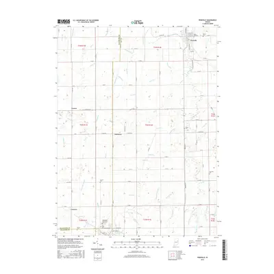
2016 Map of Pennville
USGS Topo · Published 2016About this map
Pennville sits at the northeast corner of this rural Indiana landscape, where the Salamonie River cuts across the farmland. This 2016 survey documents a region defined by its dense network of agricultural drainage, featuring numerous named waterways like Twomile Ditch and Gronendyke Ditch that crisscross the county lines of Jay and Blackford Counties. The map is particularly useful for genealogical research, identifying numerous small family and community burial grounds scattered throughout the townships, including Maple Lawn Cem and the Independent Order of Odd Fellows Cem. Small clusters of settlement such as Trenton, Ridertown, and Converse serve as local landmarks within the strictly gridded road system. The prevalence of these ditches and runs, such as Wire Run and Priam Run, illustrates the long-standing efforts to manage the naturally wet prairie lands of east-central Indiana for modern agriculture.
Find a feature on this map
92 named features on this map. Tap any name to fly to it.
Don’t see what you’re looking for? This feature index may not catch every label — zoom into the map to look around manually.
Map Details
Editions of this 2016 Pennville Map
This is the sole edition of this map. No revisions or reprints were ever made.
Other maps of this area

1953 · Muncie
USGS Topo · 1:250,000

1956 · Muncie
USGS Topo · 1:250,000

1960 · Pennville
USGS Topo · 1:24,000

1960 · Hartford City East
USGS Topo · 1:24,000

1960 · Blaine
USGS Topo · 1:24,000

1960 · Eaton
USGS Topo · 1:24,000

1960 · Ridgeville
USGS Topo · 1:24,000
1960 · Redkey
USGS Topo · 1:24,000

1962 · Montpelier
USGS Topo · 1:24,000

1962 · Petroleum
USGS Topo · 1:24,000