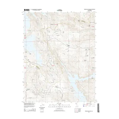
2015 Map of Penon Blanco Peak
USGS Topo · Published 2015About this map
The Tuolumne and Mariposa County line divides this landscape of high ridges and significant water storage projects. In the north, the Peñon Blanco Ridge rises above Herbeck Flat, with Peñon Blanco Peak serving as a dominant landmark. The terrain is marked by numerous gold-era canyons such as Ned Gulch, Spring Gulch, and the curiously named Picture Gallery Gulch. Settlement patterns are concentrated around localized flats and former mining sites, including Whisky Flat and Blanchard.
Find a feature on this map
122 named features on this map. Tap any name to fly to it.
Don’t see what you’re looking for? This feature index may not catch every label — zoom into the map to look around manually.
Map Details
Editions of this 2015 Penon Blanco Peak Map
This is the sole edition of this map. No revisions or reprints were ever made.
Other maps of this area

1893 · Sonora
USGS Topo · 1:125,000

1896 · Sonora
USGS Topo · 1:125,000

1897 · Sonora
USGS Topo · 1:125,000

1898 · Sonora
USGS Topo · 1:125,000

1915 · La Grange
USGS Topo · 1:24,000

1916 · Merced Falls
USGS Topo · 1:24,000
1918 · Snelling
USGS Topo · 1:31,680

1919 · La Grange
USGS Topo · 1:31,680

1919 · Merced Falls
USGS Topo · 1:31,680

1944 · Merced Falls
USGS Topo · 1:62,500