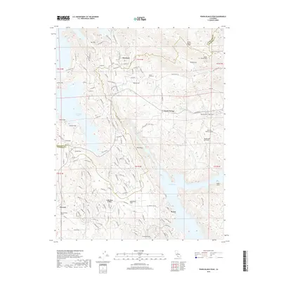
2018 Map of Penon Blanco Peak
USGS Topo · Published 2018About this map
Peñon Blanco Peak and the high ridgeline of Peñon Blanco Ridge dominate this section of the Sierra Nevada foothills on the border of Tuolumne and Mariposa counties. The landscape is defined by its relation to water, sitting between the expansive Don Pedro Reservoir to the west and Lake McClure to the south. Historically significant nodes like Granite Springs, home to the Granite Springs Cem, and the settlement at Blanchard illustrate the residential development patterns in this gold-country region. The map reveals a transition from traditional flats and gulches, such as Whisky Flat and Bonds Flat, to contemporary planned communities like Lake Don Pedro. This geographic survey preserves the names of early family-held locations and topographical landmarks like Kassabaum Flats and Jasper Point, reflecting the enduring legacy of 19th-century land use amidst 21st-century infrastructure.
Find a feature on this map
136 named features on this map. Tap any name to fly to it.
Don’t see what you’re looking for? This feature index may not catch every label — zoom into the map to look around manually.
Map Details
Editions of this 2018 Penon Blanco Peak Map
This is the sole edition of this map. No revisions or reprints were ever made.
Other maps of this area

1893 · Sonora
USGS Topo · 1:125,000

1896 · Sonora
USGS Topo · 1:125,000

1897 · Sonora
USGS Topo · 1:125,000

1898 · Sonora
USGS Topo · 1:125,000

1915 · La Grange
USGS Topo · 1:24,000

1916 · Merced Falls
USGS Topo · 1:24,000
1918 · Snelling
USGS Topo · 1:31,680

1919 · La Grange
USGS Topo · 1:31,680

1919 · Merced Falls
USGS Topo · 1:31,680

1944 · Merced Falls
USGS Topo · 1:62,500