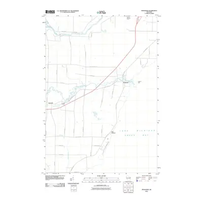
2010 Map of Pensaukee
USGS Topo · Published 2010About this map
Pensaukee River and Oconto River drain this coastal landscape as it reaches the western shore of Lake Michigan Green Bay. This era of the landscape is defined by the intersection of traditional shoreline life and modern infrastructure, where the Pensaukee Harbor Light stands near the river's mouth while the Oconto Municipal Airport occupies the northern flats. Small settlements like Brookside and Oak Orchard anchor the interior, connected by a network of rural roads such as Bell Bridge Rd and County Hwy S. Genealogists may find particular interest in the Brookside Cemetery and the numerous family-named roads like Mocco Ln and Liegeois Rd that hint at the local landholders of the early 21st century.
Find a feature on this map
42 named features on this map. Tap any name to fly to it.
Don’t see what you’re looking for? This feature index may not catch every label — zoom into the map to look around manually.
Map Details
Editions of this 2010 Pensaukee Map
This is the sole edition of this map. No revisions or reprints were ever made.
Other maps of this area

1954 · New Franken
USGS Topo · 1:62,500

1954 · Manitowoc
USGS Topo · 1:250,000

1954 · Green Bay
USGS Topo · 1:62,500

1955 · Green Bay
USGS Topo · 1:250,000

1956 · Oconto
USGS Topo · 1:62,500

1956 · Oconto Falls
USGS Topo · 1:62,500

1958 · Manitowoc
USGS Topo · 1:250,000
1974 · Oconto East
USGS Topo · 1:24,000

1974 · Abrams
USGS Topo · 1:24,000
1974 · Lena
USGS Topo · 1:24,000