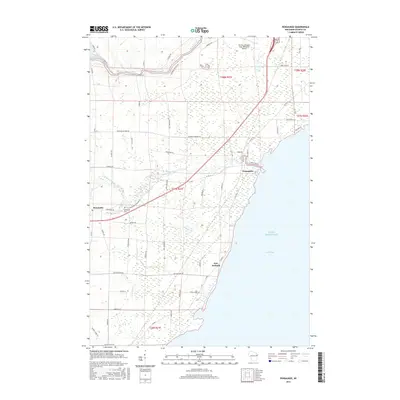
2015 Map of Pensaukee
USGS Topo · Published 2015About this map
Lake Michigan dominates the eastern horizon of this Oconto County landscape, where the waters of Green Bay meet a coastline marked by low-lying wetlands and river mouths. The Oconto River flows through the northern reaches near the Oconto-J Douglas Bake Memorial Airport, while the Pensaukee River winds eastward toward the settlement of Pensaukee. This area reflects a long-standing relationship between the land and the bay, with small communities like Brookside and Oak Orchard situated along a network of country roads such as Old State Rd and Co Hwy S.
Find a feature on this map
95 named features on this map. Tap any name to fly to it.
Don’t see what you’re looking for? This feature index may not catch every label — zoom into the map to look around manually.
Map Details
Editions of this 2015 Pensaukee Map
This is the sole edition of this map. No revisions or reprints were ever made.
Other maps of this area

1954 · New Franken
USGS Topo · 1:62,500

1954 · Manitowoc
USGS Topo · 1:250,000

1954 · Green Bay
USGS Topo · 1:62,500

1955 · Green Bay
USGS Topo · 1:250,000

1956 · Oconto
USGS Topo · 1:62,500

1956 · Oconto Falls
USGS Topo · 1:62,500

1958 · Manitowoc
USGS Topo · 1:250,000
1974 · Oconto East
USGS Topo · 1:24,000

1974 · Abrams
USGS Topo · 1:24,000
1974 · Lena
USGS Topo · 1:24,000