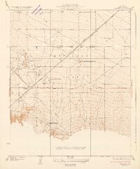
1934 Map of Pentland
USGS Topo · Published 1934About this map
Maricopa Flat serves as the industrial heart of this 1930s Kern County landscape, dominated by the infrastructure of the California oil boom. The terrain is defined by the convergence of the Sunset Railway and Maricopa Road State Highway No 57 at the settlement of Pentland. This area reveals a dense concentration of petroleum activity, including the Richfield Refining Plant No 1 and the General Petroleum Corporation Pentland Pumping Sta.
Find a feature on this map
17 named features on this map. Tap any name to fly to it.
Don’t see what you’re looking for? This feature index may not catch every label — zoom into the map to look around manually.
Map Details
Editions of this 1934 Pentland Map
2 editions found

Other maps of this area

1903 · Mt. Pinos
USGS Topo · 1:125,000

1910 · Buena Vista Lake
USGS Topo · 1:125,000

1912 · Buena Vista Lake
USGS Topo · 1:125,000

1929 · Mouth of Kern
USGS Topo · 1:31,680

1930 · Millux
USGS Topo · 1:31,680

1931 · Pentland Junction
USGS Topo · 1:31,680

1931 · Hayes Ranch
USGS Topo · 1:31,680

1932 · Mouth of Kern
USGS Topo · 1:31,680

1933 · Hayes Ranch
USGS Topo · 1:31,680
1933 · Millux
USGS Topo · 1:31,680