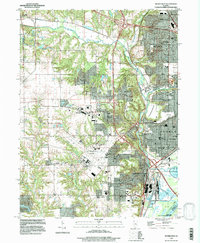
1996 Map of Peoria West
USGS Topo · Published 1997About this map
Kickapoo Creek winds through the heart of this landscape, framing the western expansion of Peoria and its neighboring industrial and residential suburbs. The map captures a mature 1990s urban fringe where long-established neighborhoods meet infrastructure hubs like the Greater Peoria Airport and the Peoria and Pekin Union Ry. Residential growth is evident in the dense clusters of Golden Acres and El Vista, while the legacy of local education and faith is anchored by sites like Limestone High Sch, Manual High Sch, and Christ Ch.
Find a feature on this map
52 named features on this map. Tap any name to fly to it.
Don’t see what you’re looking for? This feature index may not catch every label — zoom into the map to look around manually.
Map Details
Editions of this 1996 Peoria West Map
This is the sole edition of this map. No revisions or reprints were ever made.
Other maps of this area

1893 · Dunlap
USGS Topo · 1:62,500

1898 · Dunlap
USGS Topo · 1:62,500

1905 · Peoria
USGS Topo · 1:62,500

1927 · Peoria
USGS Topo · 1:62,500

1930 · Glasford
USGS Topo · 1:62,500

1932 · Dunlap
USGS Topo · 1:62,500

1933 · Dunlap
USGS Topo · 1:62,500

1937 · Dunlap
USGS Topo · 1:62,500

1944 · Elmwood
USGS Topo · 1:62,500

1948 · Elmwood
USGS Topo · 1:62,500