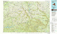
1986 Map of Pepacton Reservoir
USGS Topo · Published 1993About this map
Pepacton Reservoir and the Catskill Mountains anchor this late-twentieth-century study of the New York interior, highlighting the complex water management and rugged topography of the region. The landscape is defined by the headwaters of the East Branch Delaware River and the Schoharie Creek system, where the Schoharie Reservoir serves as a critical infrastructure point. Settlement patterns follow the narrow valleys, with many small hamlets such as North Blenheim and Kortright Station situated between high peaks like Utsayantha Mountain and Hunter Mountain.
Find a feature on this map
248 named features on this map. Tap any name to fly to it.
Don’t see what you’re looking for? This feature index may not catch every label — zoom into the map to look around manually.
Map Details
Editions of this 1986 Pepacton Reservoir Map
2 editions found
Other maps of this area

1892 · Kaaterskill
USGS Topo · 1:62,500

1893 · Kaaterskill
USGS Topo · 1:62,500

1893 · Coxsackie
USGS Topo · 1:62,500

1893 · Durham
USGS Topo · 1:62,500

1893 · Albany
USGS Topo · 1:62,500

1894 · Coxsackie
USGS Topo · 1:62,500

1894 · Kaaterskill
USGS Topo · 1:62,500

1894 · Durham
USGS Topo · 1:62,500

1895 · Catskill
USGS Topo · 1:62,500

1895 · Albany
USGS Topo · 1:62,500