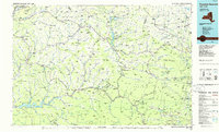
1986 Map of Pepacton Reservoir
USGS Topo · Published 1986About this map
The Pepacton Reservoir dominates the southern portion of this mid-1980s landscape, serving as a massive hydrological anchor for the western Catskill Mountains. The map traces the intricate drainage systems of the West Branch Delaware River and East Branch Delaware River, alongside the Schoharie Creek and Esopus Creek valleys. This era shows a region defined by its protected lands, with the vast Catskill Park and designated conservation zones like the Vinegar Hill State Wildlife Mgmt Area preserving the character of the high peaks.
Find a feature on this map
155 named features on this map. Tap any name to fly to it.
Don’t see what you’re looking for? This feature index may not catch every label — zoom into the map to look around manually.
Map Details
Editions of this 1986 Pepacton Reservoir Map
2 editions found
Other maps of this area

1892 · Kaaterskill
USGS Topo · 1:62,500

1893 · Kaaterskill
USGS Topo · 1:62,500

1893 · Coxsackie
USGS Topo · 1:62,500

1893 · Durham
USGS Topo · 1:62,500

1893 · Albany
USGS Topo · 1:62,500

1894 · Coxsackie
USGS Topo · 1:62,500

1894 · Kaaterskill
USGS Topo · 1:62,500

1894 · Durham
USGS Topo · 1:62,500

1895 · Catskill
USGS Topo · 1:62,500

1895 · Albany
USGS Topo · 1:62,500