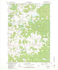
1982 Map of Peplin
USGS Topo · Published 1982About this map
The unincorporated settlement of Peplin lies at the heart of this Marathon County landscape, where agriculture and industry intersect within the townships of Kronenwetter and Guenther. In the early 1980s, the area was characterized by a grid of rural roads like Maple Ridge Road and Pioneer Road, serving a community anchored by St John the Baptist Ch and its adjacent Cem. The northern portion of the map shows the industrial presence of the Rothschild Corp and communication infrastructure including Radio Towers (WSAU) and a Radio Facility.
Find a feature on this map
44 named features on this map. Tap any name to fly to it.
Don’t see what you’re looking for? This feature index may not catch every label — zoom into the map to look around manually.
Map Details
Editions of this 1982 Peplin Map
This is the sole edition of this map. No revisions or reprints were ever made.
Other maps of this area

1899 · Wausau
USGS Topo · 1:125,000

1902 · Wausau
USGS Topo · 1:125,000

1953 · Wausau
USGS Topo · 1:48,000

1953 · Hatley
USGS Topo · 1:48,000

1955 · Rosholt
USGS Topo · 1:48,000

1955 · Green Bay
USGS Topo · 1:250,000

1956 · Stevens Point
USGS Topo · 1:48,000

1963 · Wausau West
USGS Topo · 1:24,000
1963 · Wausau East
USGS Topo · 1:24,000

1963 · Wausau
USGS Topo · 1:62,500