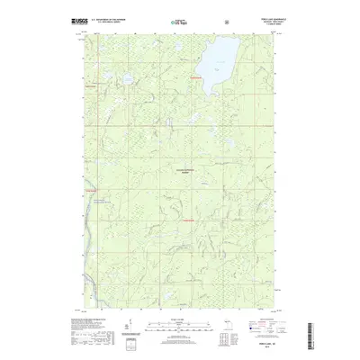
2019 Map of Perch Lake
USGS Topo · Published 2019About this map
The Ottawa National Forest dominates this landscape in Michigan's Upper Peninsula, defined by a dense network of glacial lakes and wetlands. The waterway of the Paint Wild and Scenic River and the Canoe-North Branch Paint River wind through the southwestern portion of the sheet, suggesting the area's significance for both conservation and primitive recreation. Inland, numerous small basins like Hannah Webb Lake and Petrow Lake are connected by forest service routes, including Federal Forest 2149 Rd and Perch Lake Rd. The presence of many family-named features such as Hannah Webb Lake and Ponozo Lake provides valuable geographic markers for local historians and genealogists tracking the human footprint within these public lands. Small tributaries like Stump Cr and Golden Cr drain the timbered terrain, reflecting a nearly untouched wilderness character.
Find a feature on this map
34 named features on this map. Tap any name to fly to it.
Don’t see what you’re looking for? This feature index may not catch every label — zoom into the map to look around manually.
Map Details
Editions of this 2019 Perch Lake Map
This is the sole edition of this map. No revisions or reprints were ever made.
Other maps of this area

1895 · Perch Lake
USGS Topo · 1:62,500

1898 · Iron River
USGS Topo · 1:62,500

1945 · Gibbs City
USGS Topo · 1:24,000

1945 · Sunset Lake
USGS Topo · 1:24,000

1946 · Sunset Lake
USGS Topo · 1:31,680

1946 · Gibbs City
USGS Topo · 1:31,680

1954 · Kenton
USGS Topo · 1:62,500

1954 · Perch Lake
USGS Topo · 1:62,500

1956 · Beechwood
USGS Topo · 1:62,500

1958 · Iron River
USGS Topo · 1:250,000