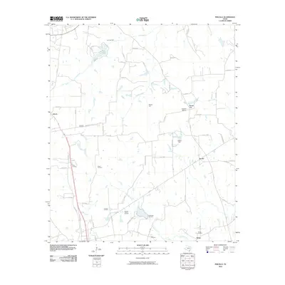
2010 Map of Percilla
USGS Topo · Published 2010About this map
San Pedro Creek and its many tributaries, including Saddler Creek and Ioni Creek, carve a detailed network across this East Texas landscape. The region is dotted with numerous family and community burial grounds that offer significant value for genealogical research, such as the Gulceville Cemetery, Dunham-Harmon Cemetery, and Enon Cemetery. Small rural settlements like Salmon, Percilla, and Mound City anchor the local road system, which consists primarily of county routes and farm-to-market roads like FM 2022. Notable water features such as Ioni Lake and Wilkins Lake are managed by private structures like the Ioni Lake Dam and Wilkins Dam, illustrating how the local drainage has been modified over time. Distinctive landmarks like Houston Mound and natural water sources including Yarborough Springs and Green Springs further define the geography of this Grapeland vicinity.
Find a feature on this map
71 named features on this map. Tap any name to fly to it.
Don’t see what you’re looking for? This feature index may not catch every label — zoom into the map to look around manually.
Map Details
Editions of this 2010 Percilla Map
This is the sole edition of this map. No revisions or reprints were ever made.
Other maps of this area

1950 · Crockett NE
USGS Topo · 1:24,000

1951 · Grapeland
USGS Topo · 1:24,000

1951 · Crockett NE
USGS Topo · 1:24,000

1951 · Elkhart
USGS Topo · 1:62,500

1952 · Slocum
USGS Topo · 1:62,500

1953 · Palestine
USGS Topo · 1:250,000

1957 · Palestine
USGS Topo · 1:250,000

1964 · Hays Spring
USGS Topo · 1:24,000

1981 · Palestine
USGS Topo · 1:100,000
1982 · Percilla
USGS Topo · 1:24,000