
Loading...
Loading map...1981 Map of Palestine
USGS Topo · Published 1981About this map
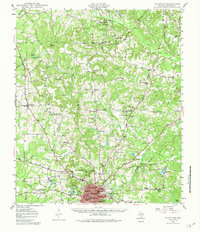
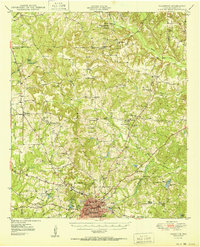
Palestine serves as the central hub of this East Texas region, where the industrial presence of a Refinery and a vast network of rail lines including the Missouri Pacific Railroad and the Texas State Railroad define the local economy. The landscape is a complex mix of agricultural land and managed wilderness, stretching from the Coffield State Prison Farm in the west to the dense timber of the Davy Crockett National Forest in the southeast.
Find a feature on this map
141 named features on this map. Tap any name to fly to it.
Don’t see what you’re looking for? This feature index may not catch every label — zoom into the map to look around manually.
Map Details
Date Portrayed1981
Date Published1981
PublisherU.S. Geological Survey
Map TypeTopographic
Scale1:100,000
Physical Dimensions43.1 x 24.1 inches
Editions of this 1981 Palestine Map
This is the sole edition of this map. No revisions or reprints were ever made.
Historical Maps of Palestine Through Time
6 maps found

Featured Locations
Source Details
SourceU.S. Geological Survey
CopyrightPublic Domain