
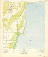
1949 Map of Perrine
USGS Topo · Published 1949About this map
The Florida East Coast railway corridor dictates the early development of this coastal landscape just after World War II, connecting the settlements of Perrine, Peters, and South Allapattah. Moving east toward the shoreline of Biscayne Bay, the grid of modern development gives way to the historic winding path of Old Cutler Road and the small coastal community of Cutler. The drainage patterns of the area are clearly defined by the Coconut Palm Canal and Black Creek, which feed into the bay near Black Pt. This survey, compiled from mid-1940s aerial photography, documents the transition of Miami-Dade County's southern reaches from agricultural and rural plots toward suburban expansion. Notable coastal features like Chicken Key and the boundary of the City of Coral Gables illustrate the mix of private land and protected waterfront that characterized the era.
Find a feature on this map
20 named features on this map. Tap any name to fly to it.
Don’t see what you’re looking for? This feature index may not catch every label — zoom into the map to look around manually.
Map Details
Editions of this 1949 Perrine Map
2 editions found
Other maps of this area

1947 · Key Biscayne
USGS Topo · 1:24,000

1948 · Soldier Key
USGS Topo · 1:24,000

1949 · South Miami NW
USGS Topo · 1:24,000

1949 · Elliott Key
USGS Topo · 1:24,000

1949 · Key Biscayne
USGS Topo · 1:24,000

1949 · Arsenicker Keys
USGS Topo · 1:24,000

1949 · Goulds
USGS Topo · 1:24,000

1950 · Homestead
USGS Topo · 1:24,000

1950 · South Miami
USGS Topo · 1:24,000

1955 · South Miami NW
USGS Topo · 1:24,000