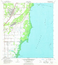
1956 Map of Perrine
USGS Topo · Published 1969About this map
Biscayne Bay defines the eastern edge of this coastal Florida landscape, where the shoreline transitions from the developed community of Cutler to the mangroves and tidal flats near Black Point. The interior reveals a mid-century pattern of suburban expansion and agricultural persistence, with the planned streets of Cutler Ridge emerging near the established tracks of the Florida East Coast railway. Inland, the settlements of Perrine, Peters, and Franjo are interconnected by a network of rural routes including Old Cutler Road and Eureka Drive.
Find a feature on this map
32 named features on this map. Tap any name to fly to it.
Don’t see what you’re looking for? This feature index may not catch every label — zoom into the map to look around manually.
Map Details
Editions of this 1956 Perrine Map
5 editions found

Other maps of this area

1947 · Key Biscayne
USGS Topo · 1:24,000

1948 · Soldier Key
USGS Topo · 1:24,000

1949 · South Miami NW
USGS Topo · 1:24,000

1949 · Elliott Key
USGS Topo · 1:24,000

1949 · Key Biscayne
USGS Topo · 1:24,000

1949 · Arsenicker Keys
USGS Topo · 1:24,000

1949 · Goulds
USGS Topo · 1:24,000

1949 · Perrine
USGS Topo · 1:24,000

1950 · Homestead
USGS Topo · 1:24,000

1950 · South Miami
USGS Topo · 1:24,000