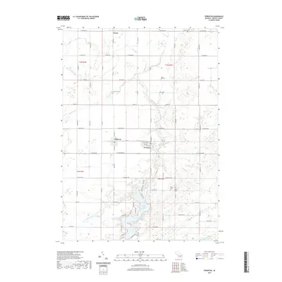
2019 Map of Perrinton
USGS Topo · Published 2019About this map
The villages of Middleton and Perrinton anchor the south-central portion of this Gratiot County landscape, situated along the corridor of E Railroad St and Cleveland Rd. The surrounding terrain is a detailed network of agricultural drainage and natural waterways, featuring the curiously named River Styx in the north and the Maple River bordering the south. Local heritage is preserved in several burial grounds scattered across the townships, including Greenwood Cem, Beechler Cem, and the neighboring Old Fulton Cem and Fulton Center Cem. This modern survey illustrates the persistent rural structure of the area, where the grid of section roads like S Ely Hwy and S Alger Rd navigates around numerous wetlands and small water bodies such as Rainbow Lake. The map provides a clear record of the small-town layout in Middleton and the varied drainage systems like Myra and Coly Drain that support the local landscape.
Find a feature on this map
77 named features on this map. Tap any name to fly to it.
Don’t see what you’re looking for? This feature index may not catch every label — zoom into the map to look around manually.
Map Details
Editions of this 2019 Perrinton Map
This is the sole edition of this map. No revisions or reprints were ever made.
Other maps of this area

1918 · Perrinton
USGS Topo · 1:62,500

1935 · Alma
USGS Topo · 1:62,500

1938 · Alma
USGS Topo · 1:62,500

1943 · Perrinton
USGS Topo · 1:62,500

1954 · Midland
USGS Topo · 1:250,000

1958 · Midland
USGS Topo · 1:250,000

1959 · Midland
USGS Topo · 1:250,000

1965 · Sumner
USGS Topo · 1:24,000
1965 · Perrinton
USGS Topo · 1:24,000
1965 · Pompeii
USGS Topo · 1:24,000