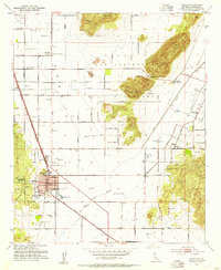
1953 Map of Perris
USGS Topo · Published 1954About this map
Perris and the surrounding San Jacinto Valley are shown here during a period of mid-century agricultural and infrastructure development. The Atchison Topeka and Santa Fe railroad serves as the primary transport corridor, passing the central Station and local landmarks like the City Hall. To the north, March Air Force Base dominates the landscape, while the Colorado River Aqueduct tunnels through the Bernasconi Hills, highlighting the critical water engineering required for the region's growth. Educational and social institutions are well-represented, including the Palomar Sch for Boys, Nuview Union School, and the Lakeview Hot Springs. The map documents the intricate network of orchards and fields served by roads like Citrus Ave and Orange Avenue, alongside technical aviation markers like the Gregory Radio Range Sta and the Omni Radio Range Sta.
Find a feature on this map
62 named features on this map. Tap any name to fly to it.
Don’t see what you’re looking for? This feature index may not catch every label — zoom into the map to look around manually.
Map Details
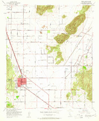
Editions of this 1953 Perris Map
2 editions found
Other maps of this area

1901 · Southern California Sheet No. 1
USGS Topo · 1:250,000

1901 · Elsinore
USGS Topo · 1:125,000

1901 · Riverside
USGS Topo · 1:62,500

1904 · Southern California Sheet No. 1
USGS Topo · 1:250,000

1942 · Lake Elsinore
USGS Topo · 1:62,500

1942 · Murrieta
USGS Topo · 1:62,500

1942 · Riverside
USGS Topo · 1:62,500

1942 · Perris
USGS Topo · 1:62,500

1943 · Perris
USGS Topo · 1:62,500

1943 · Riverside
USGS Topo · 1:62,500