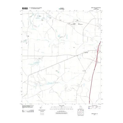
2011 Map of Perry West
USGS Topo · Published 2011About this map
Saint Louis and Myrtle anchor the rural and suburban landscapes of Houston County in this detailed 2011 survey. The terrain is characterized by a series of engineered water bodies and dams, including Lucy Giles Lake, Forbes Lake, and Lake Lasseter, which follow the drainage of Big Indian Creek and Flat Creek. This network of private and community lakes suggests a history of land management and recreational development on the western outskirts of the Perry area. Residential growth is evident in several named developments like Bonnie Brae Subdivision and Meadowdale. For those researching local family history, Hoses Cemetery and the Camp Hope school site provide important community touchstones amidst the expanding infrastructure of Perry Pkwy and the northern reaches of Hogcrawl Creek.
Find a feature on this map
64 named features on this map. Tap any name to fly to it.
Don’t see what you’re looking for? This feature index may not catch every label — zoom into the map to look around manually.
Map Details
Editions of this 2011 Perry West Map
This is the sole edition of this map. No revisions or reprints were ever made.
Other maps of this area

1956 · Fort Valley
USGS Topo · 1:62,500

1956 · Perry
USGS Topo · 1:62,500

1956 · Warner Robins
USGS Topo · 1:62,500

1957 · Macon
USGS Topo · 1:250,000

1958 · Macon
USGS Topo · 1:250,000

1964 · Macon
USGS Topo · 1:250,000

1971 · Henderson
USGS Topo · 1:24,000
1972 · Marshallville
USGS Topo · 1:24,000
1972 · Marshallville SW
USGS Topo · 1:24,000

1972 · Perry West
USGS Topo · 1:24,000