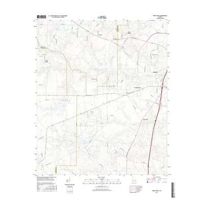
2017 Map of Perry West
USGS Topo · Published 2017About this map
The boundary between Peach, Macon, and Houston counties converges in this central Georgia landscape, where the outskirts of Perry give way to a network of rural settlements and agricultural roads. Small communities such as Myrtle, Clopine, and Saint Louis anchor the northern and western sections, connected by thoroughfares like Old Perry Rd and Marshallville Rd. The area is notably dense with water features, including named impoundments like Lake Clopine, Dumas Lake, and Free Lake, many of which feed into larger systems like Big Indian Cr or Flat Creek.
Find a feature on this map
74 named features on this map. Tap any name to fly to it.
Don’t see what you’re looking for? This feature index may not catch every label — zoom into the map to look around manually.
Map Details
Editions of this 2017 Perry West Map
This is the sole edition of this map. No revisions or reprints were ever made.
Other maps of this area

1956 · Fort Valley
USGS Topo · 1:62,500

1956 · Perry
USGS Topo · 1:62,500

1956 · Warner Robins
USGS Topo · 1:62,500

1957 · Macon
USGS Topo · 1:250,000

1958 · Macon
USGS Topo · 1:250,000

1964 · Macon
USGS Topo · 1:250,000

1971 · Henderson
USGS Topo · 1:24,000
1972 · Marshallville
USGS Topo · 1:24,000
1972 · Marshallville SW
USGS Topo · 1:24,000

1972 · Perry West
USGS Topo · 1:24,000