Loading...
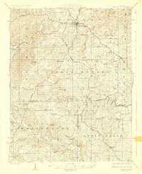
Loading map...1924 Map of Perryville
USGS Topo · Published 1924About this map
Perryville serves as the focal point of this 1920s survey, anchoring a region defined by the winding course of the Whitewater River and Apple Creek. The landscape is a network of small agricultural settlements and family-named schools, including Rock Valley School and Duggins School, illustrating the rural school district system of early 20th-century Missouri. Industrial and religious life are prominent through features like Bollingers Mill and St Marys Seminary.
Find a feature on this map
74 named features on this map. Tap any name to fly to it.
Don’t see what you’re looking for? This feature index may not catch every label — zoom into the map to look around manually.
Map Details
Date Portrayed1924
Date Published1924
PublisherU.S. Geological Survey
Map TypeTopographic
Scale1:62,500
Physical Dimensions16.25 x 19.88 inches
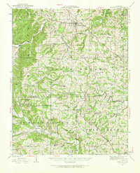
Editions of this 1924 Perryville Map
2 editions found

Historical Maps of Perryville Through Time
Featured Locations
Source Details
SourceU.S. Geological Survey
CopyrightPublic Domain