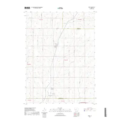
2018 Map of Persia
USGS Topo · Published 2018About this map
The settlement of Persia serves as the primary hub in this western Iowa landscape, situated along the upper reaches of Mosquito Cr. This 2018 survey documents a region defined by its complex drainage network and agricultural heritage, where several small cemeteries such as Chambers Cem, Lytle Cem, and Schley Cem are preserved among the fields. To the south, the community of Yorkshire sits near the confluence of local tributaries, marking a secondary point of historical settlement near the border of Pottawattamie County. Genealogists will find particular value in the distribution of family burial grounds like Champlin Cem and Graybill Cem, which remain as anchor points for local history. The land is intricately carved by waterways including Pigeon Cr, Spring Cr, and Keg Cr, illustrating the topographical texture of Harrison County.
Find a feature on this map
95 named features on this map. Tap any name to fly to it.
Don’t see what you’re looking for? This feature index may not catch every label — zoom into the map to look around manually.
Map Details
Editions of this 2018 Persia Map
This is the sole edition of this map. No revisions or reprints were ever made.
Other maps of this area

1954 · Omaha
USGS Topo · 1:250,000

1956 · Underwood
USGS Topo · 1:24,000

1956 · Neola
USGS Topo · 1:24,000

1957 · Omaha
USGS Topo · 1:250,000

1958 · Omaha
USGS Topo · 1:250,000

1963 · Avoca NW
USGS Topo · 1:24,000
1978 · Hard Scratch
USGS Topo · 1:24,000

1978 · Panama
USGS Topo · 1:24,000

1978 · Persia
USGS Topo · 1:24,000
1978 · Woodbine
USGS Topo · 1:24,000