
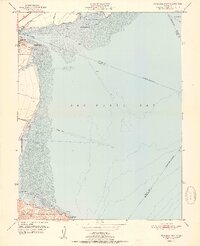
1951 Map of Petaluma Point
USGS Topo · Published 1951About this map
San Pablo Bay dominates this mid-century survey, revealing the complex hydrologic and industrial edge of the northern San Francisco Bay. Extensive mud flats and marshlands are defined by a network of engineered features, including a prominent Levee system protecting Tubbs Island and multiple navigation aids such as a Beacon and various Markers. The map documents the northern entry of Petaluma Creek and the tidal reaches of Novato Cr and Gallinas Creek.
Find a feature on this map
28 named features on this map. Tap any name to fly to it.
Don’t see what you’re looking for? This feature index may not catch every label — zoom into the map to look around manually.
Map Details
Editions of this 1951 Petaluma Point Map
2 editions found
Historical Maps of Vallejo Through Time
58 maps found

1897 Tamalpais
Marin County, CA

1916 Point Reyes
Marin County, CA

1918 Point Reyes
Marin County, CA

1941 Tamalpais
Marin County, CA

1947 San Quentin
Marin County, CA

1948 San Quentin
Marin County, CA

1950 Mt. Tamalpais
Marin County, CA
1951 Petaluma Point
Marin County, CA

1953 Drakes Bay
Marin County, CA

1954 Double Point
Marin County, CA

1954 Point Bonita
Marin County, CA

1954 Point Reyes
Marin County, CA

1954 Point Reyes NE
Marin County, CA

1959 Petaluma Point
Marin County, CA

1959 San Quentin
Marin County, CA

1993 Double Point
Marin County, CA

1993 Point Bonita
Marin County, CA

1993 San Quentin
Marin County, CA

1994 Double Point
Marin County, CA

1995 Drakes Bay
Marin County, CA

1995 Point Reyes NE
Marin County, CA

1995 San Quentin
Marin County, CA

2012 Double Point
Marin County, CA

2012 Drakes Bay
Marin County, CA

2012 Drakes Bay OE S
Marin County, CA

2012 Drakes Bay OE SW
Marin County, CA

2012 Drakes Bay OE W
Marin County, CA

2012 Petaluma Point
Marin County, CA

2012 Point Bonita
Marin County, CA

2012 Point Reyes NE
Marin County, CA

2012 San Quentin
Marin County, CA

2015 Double Point
Marin County, CA

2015 Drakes Bay
Marin County, CA

2015 Drakes Bay OE S
Marin County, CA

2015 Drakes Bay OE SW
Marin County, CA

2015 Drakes Bay OE W
Marin County, CA

2015 Petaluma Point
Marin County, CA

2015 Point Bonita
Marin County, CA

2015 Point Reyes NE
Marin County, CA

2015 San Quentin
Marin County, CA

2018 Double Point
Marin County, CA

2018 Drakes Bay
Marin County, CA

2018 Drakes Bay OE S
Marin County, CA

2018 Drakes Bay OE SW
Marin County, CA

2018 Drakes Bay OE W
Marin County, CA

2018 Petaluma Point
Marin County, CA

2018 Point Bonita
Marin County, CA

2018 Point Reyes NE
Marin County, CA

2018 San Quentin
Marin County, CA

2021 Double Point
Marin County, CA

2021 Drakes Bay
Marin County, CA

2021 Drakes Bay OE S
Marin County, CA

2021 Drakes Bay OE SW
Marin County, CA

2021 Drakes Bay OE W
Marin County, CA

2021 Point Bonita
Marin County, CA

2021 Point Reyes NE
Marin County, CA

2021 San Quentin
Marin County, CA

2022 Petaluma Point
Marin County, CA