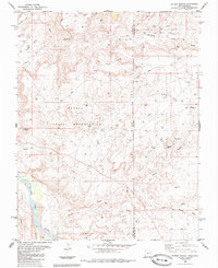
1985 Map of Peters Nipple
USGS Topo · Published 1985About this map
Navajo Indian Reservation lands and the Ute Mountain Indian Reservation converge here along the state boundary where San Juan County meets Montezuma County. This arid landscape is defined by its drainage basins and energy extraction, with a dense network of Oil Wells and a prominent Pipeline cutting across the desert floor toward Rockwell Flat. The terrain is marked by distinctive geological features like the sandstone spire of Peters Nipple and the high vantage of Aneth Point.
Find a feature on this map
19 named features on this map. Tap any name to fly to it.
Don’t see what you’re looking for? This feature index may not catch every label — zoom into the map to look around manually.
Map Details
Editions of this 1985 Peters Nipple Map
This is the sole edition of this map. No revisions or reprints were ever made.
Other maps of this area

1886 · Abajo
USGS Topo · 1:250,000

1892 · Abajo
USGS Topo · 1:250,000

1893 · Abajo
USGS Topo · 1:250,000

1956 · Cortez
USGS Topo · 1:250,000

1957 · Moqui SW
USGS Topo · 1:24,000

1958 · Sentinel Peak NW
USGS Topo · 1:24,000

1958 · Cortez
USGS Topo · 1:250,000

1958 · Aneth 1 SW
USGS Topo · 1:24,000
1958 · Aneth 1 SE
USGS Topo · 1:24,000

1958 · Cajon Mesa
USGS Topo · 1:62,500