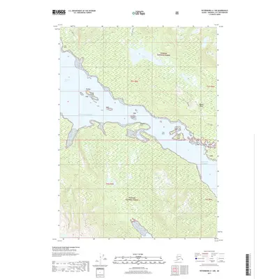
2017 Map of Petersburg A-1 NW
USGS Topo · Published 2017About this map
Zimovia Strait defines the maritime character of this region, separating mainland forest from the complex coastline of the Tongass National Forest. The small settlement at Thoms Place sits at the head of a sheltered inlet, serving as a primary point of human presence in an otherwise untamed coastal landscape. Steep topography is evident at Deer Ridge, which overlooks the interconnected waterways of the Gulf of Alaska. Navigational landmarks such as Whaletail Point, Turn Point, and the Zimovia Islets mark the passage through these waters. Inland, Thoms Lake and the associated Thoms Lake Trail suggest a reliance on water-to-land transit routes. The map documents a classic Southeast Alaska coastal pattern, where life and movement are dictated by the deep channels and rocky shorelines of the archipelago.
Find a feature on this map
22 named features on this map. Tap any name to fly to it.
Don’t see what you’re looking for? This feature index may not catch every label — zoom into the map to look around manually.
Map Details
Editions of this 2017 Petersburg A-1 NW Map
This is the sole edition of this map. No revisions or reprints were ever made.
Other maps of this area

1948 · Petersburg A-1
USGS Topo · 1:63,360

1948 · Petersburg A-2
USGS Topo · 1:63,360

1948 · Petersburg B-2
USGS Topo · 1:63,360

1948 · Petersburg B-1
USGS Topo · 1:63,360

1951 · Petersburg A-1
USGS Topo · 1:63,360

1952 · Petersburg
USGS Topo · 1:250,000

1953 · Petersburg A-2
USGS Topo · 1:63,360

1953 · Petersburg B-2
USGS Topo · 1:63,360

1955 · Petersburg B-1
USGS Topo · 1:63,360

1960 · Petersburg
USGS Topo · 1:250,000