
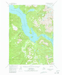
1955 Map of Petersburg B-1
USGS Topo · Published 1964About this map
Wrangell Island dominates this mid-century topographic study, defined by the intricate waterways that separate it from the Alaskan mainland. The Eastern Passage and Blake Channel meet at The Narrows, forming a vital marine corridor punctuated by landmarks like Channel Island and Point Madan. Inland from the coast, the terrain rises sharply toward glacial features such as the Nelson Glacier and the elevated Glacier Basin. Evidence of early resource extraction and seasonal habitation appears near the mouth of Mill Creek, where a Mine is located near Virginia Lake. Small clusters of Cabins are noted along the shoreline, particularly near the sheltered waters of Madan Bay, illustrating the area's historical reliance on coastal access for transit and industry during the 1950s.
Find a feature on this map
42 named features on this map. Tap any name to fly to it.
Don’t see what you’re looking for? This feature index may not catch every label — zoom into the map to look around manually.
Map Details
Editions of this 1955 Petersburg B-1 Map
2 editions found
Other maps of this area

1948 · Petersburg A-1
USGS Topo · 1:63,360

1948 · Petersburg A-2
USGS Topo · 1:63,360

1948 · Petersburg C-1
USGS Topo · 1:63,360

1948 · Petersburg C-2
USGS Topo · 1:63,360

1948 · Petersburg B-2
USGS Topo · 1:63,360

1948 · Petersburg B-1
USGS Topo · 1:63,360

1951 · Bradfield Canal
USGS Topo · 1:250,000

1951 · Petersburg C-2
USGS Topo · 1:63,360

1951 · Petersburg A-1
USGS Topo · 1:63,360

1952 · Petersburg
USGS Topo · 1:250,000