
1951 Map of Petersburg C-2
USGS Topo · Published 1965About this map
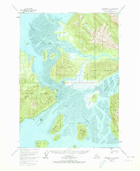
Dry Island and Farm Island anchor this coastal survey, where the massive freshwater discharge of the Stikine River meets the saltwater of Frederick Sound. This mid-century snapshot reveals a landscape defined by shifting sediments and intricate waterways like King Slough and Mallard Slough. The intricate network of Koknuk Flats illustrates the transition between the glacial runoff of the Wilkes Range and the deep coastal passages. Local landmarks such as Garnet Ledge near Garnet Mtn suggest the area's mineral interests, while scattered cabins and Camp I indicate seasonal activity and small-scale settlement. The presence of a single Highway on Mitkof Island contrasts with the primarily water-based transport through Eastern Passage and the Dry Strait, highlighting the isolation and maritime dependence of these island communities before modern infrastructure expanded.
Find a feature on this map
50 named features on this map. Tap any name to fly to it.
Don’t see what you’re looking for? This feature index may not catch every label — zoom into the map to look around manually.
Map Details
Editions of this 1951 Petersburg C-2 Map
2 editions found
Other maps of this area

1948 · Petersburg C-1
USGS Topo · 1:63,360

1948 · Petersburg C-2
USGS Topo · 1:63,360

1948 · Petersburg B-2
USGS Topo · 1:63,360

1948 · Petersburg B-1
USGS Topo · 1:63,360

1948 · Petersburg C-3
USGS Topo · 1:63,360

1948 · Petersburg B-3
USGS Topo · 1:63,360

1951 · Petersburg B-3
USGS Topo · 1:63,360

1952 · Petersburg
USGS Topo · 1:250,000

1953 · Petersburg C-1
USGS Topo · 1:63,360

1953 · Petersburg B-2
USGS Topo · 1:63,360