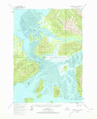
1951 Map of Petersburg C-2
USGS Topo · Published 1973About this map
The Stikine River delta dominates this mid-century coastal survey, where a complex network of channels and mud flats define the region's geography. The map illustrates the critical water-based infrastructure of the era, showing scattered cabins and a farm established along the tidal reaches. On Mitkof Island, the early route of the Mitkof Highway follows the shoreline, providing a land link near significant landmarks like Manzanita Peak and Sam Peak.
Find a feature on this map
62 named features on this map. Tap any name to fly to it.
Don’t see what you’re looking for? This feature index may not catch every label — zoom into the map to look around manually.
Map Details
Editions of this 1951 Petersburg C-2 Map
2 editions found
Other maps of this area

1948 · Petersburg C-1
USGS Topo · 1:63,360

1948 · Petersburg C-2
USGS Topo · 1:63,360

1948 · Petersburg B-2
USGS Topo · 1:63,360

1948 · Petersburg B-1
USGS Topo · 1:63,360

1948 · Petersburg C-3
USGS Topo · 1:63,360

1948 · Petersburg B-3
USGS Topo · 1:63,360

1951 · Petersburg B-3
USGS Topo · 1:63,360

1951 · Petersburg C-2
USGS Topo · 1:63,360

1952 · Petersburg
USGS Topo · 1:250,000

1953 · Petersburg C-1
USGS Topo · 1:63,360